Hi ORS team,
Here is the route. The range of this elevation profile from 10,000 m to 20,000 m. The distance is 25.8 km.
Can you help this issue? Thanks in advance for your help.
Cheers,
Zheng-Xiang
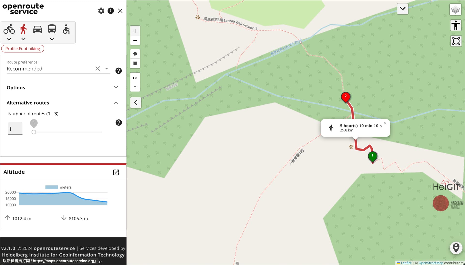
Hi ORS team,
Here is the route. The range of this elevation profile from 10,000 m to 20,000 m. The distance is 25.8 km.
Can you help this issue? Thanks in advance for your help.
Cheers,
Zheng-Xiang
Hey,
clicking on your link leads me to a map with two waypoints, between which no route could be found.
Best regards
Hi @jschnell,
Strange, I can see the route normally (screenshot is below).
Here is the route ORS JSON:
{"polygons":[],"options":{"zoom":18,"profile":"foot-hiking","preference":"recommended"},"places":[{"lng":113.91593,"lat":22.24745,"placeName":"一樹坡橫山徑, 香港,CW,香港","unresolved":false,"suggestions":[],"coordinates":[113.91593,22.24745],"properties":{},"direct":false},{"lng":113.91570210456848,"lat":22.24791730413737,"placeName":"一樹坡橫山徑, 香港,CW,香港","unresolved":false,"suggestions":[],"coordinates":[113.91570210456848,22.24791730413737],"properties":{},"direct":false}],"pois":[],"routes":[{"bbox":[113.915717,22.24745,12342.18,113.91593,22.247927,19844.38],"type":"Feature","properties":{"ascent":1012.4,"descent":8106.3,"transfers":0,"fare":0,"segments":[{"distance":25.848,"duration":18610.6,"steps":[{"distance":25.848,"duration":18610.6,"type":11,"instruction":"Head north on <b>鳳凰徑第3段 Lantau Trail Section 3</b>","name":"鳳凰徑第3段 Lantau Trail Section 3","way_points":[0,7]},{"distance":0,"duration":0,"type":10,"instruction":"Arrive at 鳳凰徑第3段 Lantau Trail Section 3, on the left","name":"-","way_points":[7,7]}],"ascent":1012.4044921874993,"descent":8106.2578125}],"extras":{"surface":{"values":[[0,7,0]],"summary":[{"value":0,"distance":0.026,"amount":100}]},"waytypes":{"values":[[0,7,7]],"summary":[{"value":7,"distance":0.026,"amount":100}]},"steepness":{"values":[[0,2,-5],[2,5,5],[5,7,-5]],"summary":[{"value":-5,"distance":0.022,"amount":83.64},{"value":5,"distance":0.004,"amount":16.36}]}},"way_points":[0,7],"summary":{"distance":25.848,"duration":18610.6},"opacity":0.9},"geometry":{"coordinates":[[113.91593,22.24745,19436],[113.915923,22.247562,18832],[113.915905,22.247585,18997],[113.915855,22.247551,19371.5],[113.915794,22.247557,19844.4],[113.915758,22.247831,15273.7],[113.915757,22.247874,13645.1],[113.915717,22.247927,12342.2]],"type":"LineString"},"summary":{"distance":25.848,"duration":18610.6,"descent":8106.3,"ascent":1012.4,"unit":"km","originalUnit":"km"}}],"origin":"response","mode":"directions","isRouteData":true,"rawData":{"type":"FeatureCollection","metadata":{"attribution":"openrouteservice.org | OpenStreetMap contributors","service":"routing","timestamp":1708490549248,"query":{"coordinates":[[113.91593,22.24745],[113.91570210456848,22.24791730413737]],"profile":"foot-hiking","preference":"recommended","format":"geojson","units":"km","language":"en","instructions_format":"html","elevation":true,"extra_info":["surface","steepness","waytype"]},"engine":{"version":"7.1.1","build_date":"2024-02-02T13:49:47Z","graph_date":"2024-02-12T22:24:00Z"}},"bbox":[113.915717,22.24745,12342.18,113.91593,22.247927,19844.38],"features":[{"bbox":[113.915717,22.24745,12342.18,113.91593,22.247927,19844.38],"type":"Feature","properties":{"ascent":1012.4,"descent":8106.3,"transfers":0,"fare":0,"segments":[{"distance":25.848,"duration":18610.6,"steps":[{"distance":25.848,"duration":18610.6,"type":11,"instruction":"Head north on <b>鳳凰徑第3段 Lantau Trail Section 3</b>","name":"鳳凰徑第3段 Lantau Trail Section 3","way_points":[0,7]},{"distance":0,"duration":0,"type":10,"instruction":"Arrive at 鳳凰徑第3段 Lantau Trail Section 3, on the left","name":"-","way_points":[7,7]}],"ascent":1012.4044921874993,"descent":8106.2578125}],"extras":{"surface":{"values":[[0,7,0]],"summary":[{"value":0,"distance":0.026,"amount":100}]},"waytypes":{"values":[[0,7,7]],"summary":[{"value":7,"distance":0.026,"amount":100}]},"steepness":{"values":[[0,2,-5],[2,5,5],[5,7,-5]],"summary":[{"value":-5,"distance":0.022,"amount":83.64},{"value":5,"distance":0.004,"amount":16.36}]}},"way_points":[0,7],"summary":{"distance":25.848,"duration":18610.6}},"geometry":{"coordinates":[[113.91593,22.24745,19436],[113.915923,22.247562,18832],[113.915905,22.247585,18997],[113.915855,22.247551,19371.5],[113.915794,22.247557,19844.4],[113.915758,22.247831,15273.7],[113.915757,22.247874,13645.1],[113.915717,22.247927,12342.2]],"type":"LineString"},"summary":{"distance":25.848,"duration":18610.6,"descent":8106.3,"ascent":1012.4,"unit":"km","originalUnit":"km"}}]},"timestamp":1708490549248}
Hey,
yes, that was a misconfiguration of the client on my part, sorry for that.
This is indeed strange - I’d guess that the wrong distance is a result of the wrong elevation.
I’ll open an issue for that.
EDIT: Issue is here
Best regards
Hey,
I get the same kind of error here: OpenRouteService route planner - directions, isochrones and places
altitude shows a gap of 162185.8 m in a flat road at sea level with cycling-mountain profile.
Best regards
Thanks @Cyprien_Taque for providing another quite prominent example. I’ve added it to the description at cycling-moutain router sometimes reports invalid elevations · Issue #2273 · GIScience/openrouteservice · GitHub.