Hello, I’ve got the following request:
https://api.openrouteservice.org/v2/directions/driving-hgv/json
{"coordinates":[[55.38139,25.35002],[55.389698,25.356456]],"options":{"vehicle_type":"bus"}}
If we look at the starting position:
And the directions output it gives me:
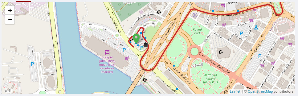
You can see that it’s avoiding the bus station, even though the vehicle type is a bus?
You guys are probably better at this, but here are some of the tags:
All of them have “bus=yes”.
If I narrow down the radius, and play around with that, unless it can snap onto the main road, it fails with “could not find routable point”. So I doubt it has to do with weights or anything like that
Anyways here’s the json from the playground:
{"bbox":[55.38086,25.348354,55.389691,25.357175],"routes":[{"summary":{"distance":1904.1,"duration":247.3},"segments":[{"distance":1904.1,"duration":247.3,"steps":[{"distance":51.5,"duration":6.2,"type":11,"instruction":"Head northwest on شارع الكورنيش","name":"شارع الكورنيش","way_points":[0,2]},{"distance":134.9,"duration":19.4,"type":1,"instruction":"Turn right","name":"-","way_points":[2,9]},{"distance":22.7,"duration":5.4,"type":1,"instruction":"Turn right","name":"-","way_points":[9,11]},{"distance":454,"duration":66.8,"type":1,"instruction":"Turn right","name":"-","way_points":[11,38]},{"distance":192.8,"duration":25.5,"type":6,"instruction":"Continue straight onto شارع العروبة","name":"شارع العروبة","way_points":[38,41]},{"distance":728.6,"duration":79.2,"type":12,"instruction":"Keep left","name":"-","way_points":[41,50]},{"distance":117.8,"duration":12.1,"type":13,"instruction":"Keep right","name":"-","way_points":[50,53]},{"distance":178.2,"duration":24.8,"type":13,"instruction":"Keep right onto شارع الغوير","name":"شارع الغوير","way_points":[53,63]},{"distance":6.8,"duration":4.9,"type":0,"instruction":"Turn left","name":"-","way_points":[63,64]},{"distance":16.8,"duration":3,"type":1,"instruction":"Turn right","name":"-","way_points":[64,65]},{"distance":0,"duration":0,"type":10,"instruction":"Arrive at your destination, on the left","name":"-","way_points":[65,65]}]}],"bbox":[55.38086,25.348354,55.389691,25.357175],"geometry":"ocvyCms_qIWXo@f@]OSOEIGWG[GI}AcABSJS`@L`@BVCLELGRURO\\IPK\\G^RxA`Al@XT@RARGPKLMJOFSF]Gm@GQKQMMQK{@e@sCcBk@_@cBgAcG_By@QyCeBs@c@aFyC{AcAmCeB{A_AeAo@UUs@g@eBaAW]CGCSBI`@s@HQBEn@sA\\q@HSIEN[","way_points":[0,65]}],"metadata":{"attribution":"openrouteservice.org | OpenStreetMap contributors","service":"routing","timestamp":1748943842073,"query":{"coordinates":[[55.38139,25.35002],[55.389698,25.356456]],"profile":"driving-hgv","profileName":"driving-hgv","format":"json","options":{"vehicle_type":"bus"}},"engine":{"version":"9.2.0","build_date":"2025-05-06T08:31:01Z","graph_date":"2025-05-26T05:53:10Z"}}}
At this point, it feels like I’m missing something basic, but I’ve gone over every parameter on that site and couldn’t find anything that could let me drive this.