Ladies and Gentlemen
after creating the isochrones on the website, I wanted to transfer the data into the ArcGIS Pro program.
Unfortunately, however, only the set point was transmitted and not the created line (isochrones / time) around the set point.
It would be great if you could help me to transfer the determined isochrones (line) in addition to the set point.
Thanks in advance!
(Sehr geehrte Damen und Herren,
nachdem ich die Isochronen auf der Website erstellt habe, wollte ich die Daten in das Programm ArcGIS Pro überspielen.
Leider wurde jedoch nur der gesetzte Punkt übertragen und nicht die erstelle Linie (Isochronen / Zeit) um den gesetzten Punkt.
Es wäre super, wenn Sie mir helfen könnten, neben dem gesetzten Punkt auch die ermittelte Isochronen (Linie) zu übertragen.
Vielen Dank im Voraus!)
Hey,
the best way to do this is to use our public API.
You can find the documentation here. The GeoJSON endpoint returns data that can be easily consumed in ArcGIS.
Otherwise I wouldn’t quite understand how you transferred the data from the website to ArcGIS. Can you elaborate on that a little more?
(nutze hierfür am besten unsere öffentlich REST-ähnliche API.
Die Dokumentation findest du hier. Der GeoJSON-Endpunkt liefert Daten zurück, die sich problemlos in ArcGIS nutzen lassen.
Ansonsten wäre mir nicht ganz klar, wie du die Daten von der Website nach ArcGIS übertragen hast. Kannst du das noch ein bisschen ausführen?)
Lieben Gruß 
Hi @BSchwarz,
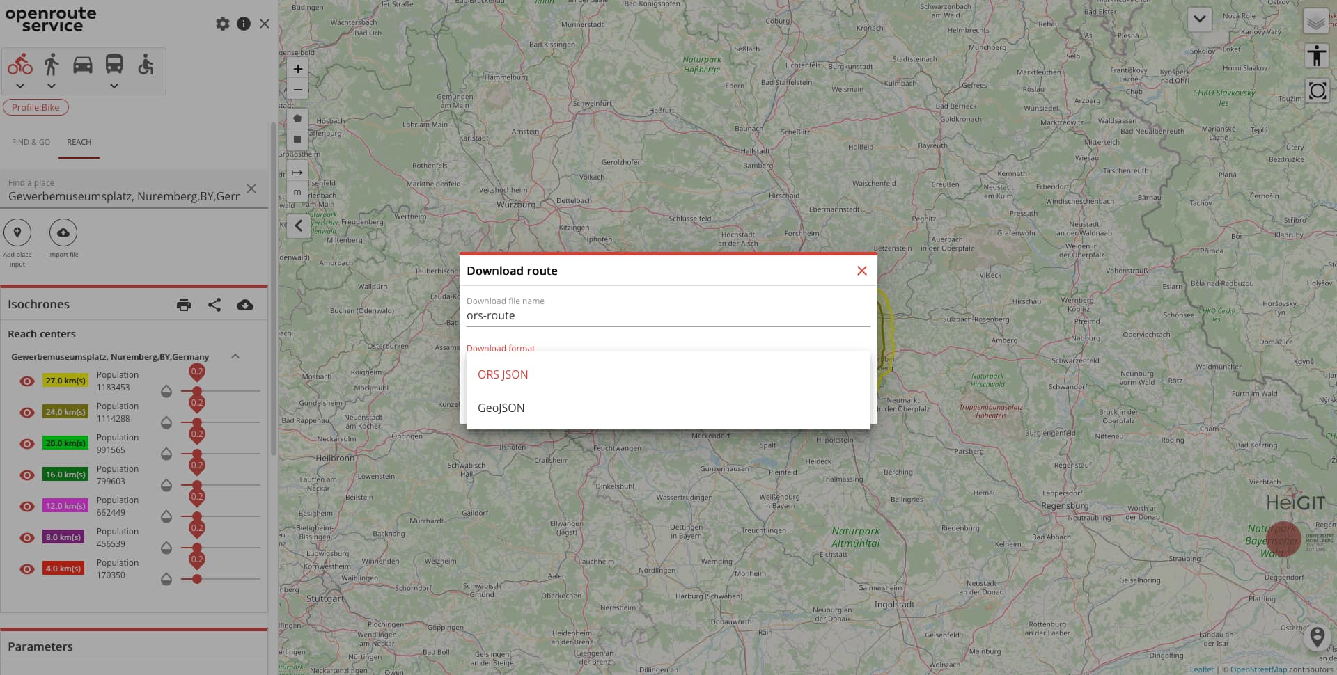
normally you can also download the isochrones directly from the website as GeoJSON if you click on
(normalerweise kann man die Isochronen auch von der Webseite direkt als GeoJSON herunterladen wen man auf)

clickt :
And as Jakob says, ArcGis should be able to import that.
(Und wie Jakob sagt, ArcGis sollte das importieren können.)
Best regards
Hey Jakob and Amandus,
Thank you very much for your quick response.
Unfortunately i can´t open the link which Jakob has sent to me.
Other than that i can download the data as a GEOJSON and import it to ARCGIS Pro (as Amandus said). But only the addresses were shown in GIS system and NOT the Isochrones (the radiuses) I have created in openroute services (for example the 3min radius around my address is not shown in GIS).
Maybe you have an idea how this will work.
Thanks a lot.
Best reagrds
Hey,
yeah, seems like I dropped a letter in copy-pasting… This link to our docs should work
Pay attention that you select GeoJSON when exporting data from the maps client.
Could you paste a minimal (not) working example of a geojson file that you exported, to see whether something goes awry there? You can also try to visualize your geojson file on something like geojson.io to check integrity.
Best regards
Hey,
Thanks a lot!
Is there a possibility to treat in contact with you via phone maybe?
It is easier to show you the issue in a short meeting.
Have a nice afternoon.
Hey,
unfortunately, we don’t offer telephone support for these kind of issues.
You can, however, try using screenshots (they’re built-in to most modern browsers and operating systems by now) or screencasts (that might require external tools, but should be fairly easy to do).
Best regards