I have made a small app for creating random walking routes on the map, a chosen distance away. For example, I can choose a walk of 500 metres and the app picks a random location that distance away, and openrouteservice provides the path from where I am to the destination. I’m finding that sometimes the route veers dramatically off in one direction before looping tortuously back to the destination icon when there are many much more direct alternatives. Could it be that there is information lacking in the database (missing waypoints etc) that prevents openrouteservice from providing a more direct path? If so, is there a way to improve the service by directly providing feedback to openrouteservice of the missing information?
Relevant information:
I am very new to maps etc so I don’t know what I don’t know yet.
I live in Viet Nam - would that affect the degree of accurate information on the map database
I have coded the app using MIT App Inventor2 so, while I can and do code in Python etc, I’m not really sure of what’s going on under the hood as far as the app is concerned
Hi @Ross_Munro
If I got it right you you have created an application that interacts with the ORS API and it displays the results in a custom interface. If that is the case, then, your question is in the wrong category, since Maps Website is for cases related to our maps client maps.openrouteservice.org. In this case, your question should be posted in the category 5 → please check the link openrouteservice - openrouteservice
All the best
That’s really helpful, thanks. I think I’ve got it in the right place now. - although I’ve since been into openmaps and that may be where I need to ask. It’s a steep learning curve.
Hi @Ross_Munro,
could you give an example request (ors endpoint and body or request parameters) for this?
ORS is using OpenStreetMap as databasis, so if there is something missing or wrong, it will have to be changed there if it is a data issue.
If it is to do with route generation you can either ask here or directly create a new issue in our backend repository if there is none for the problem.
Best regards
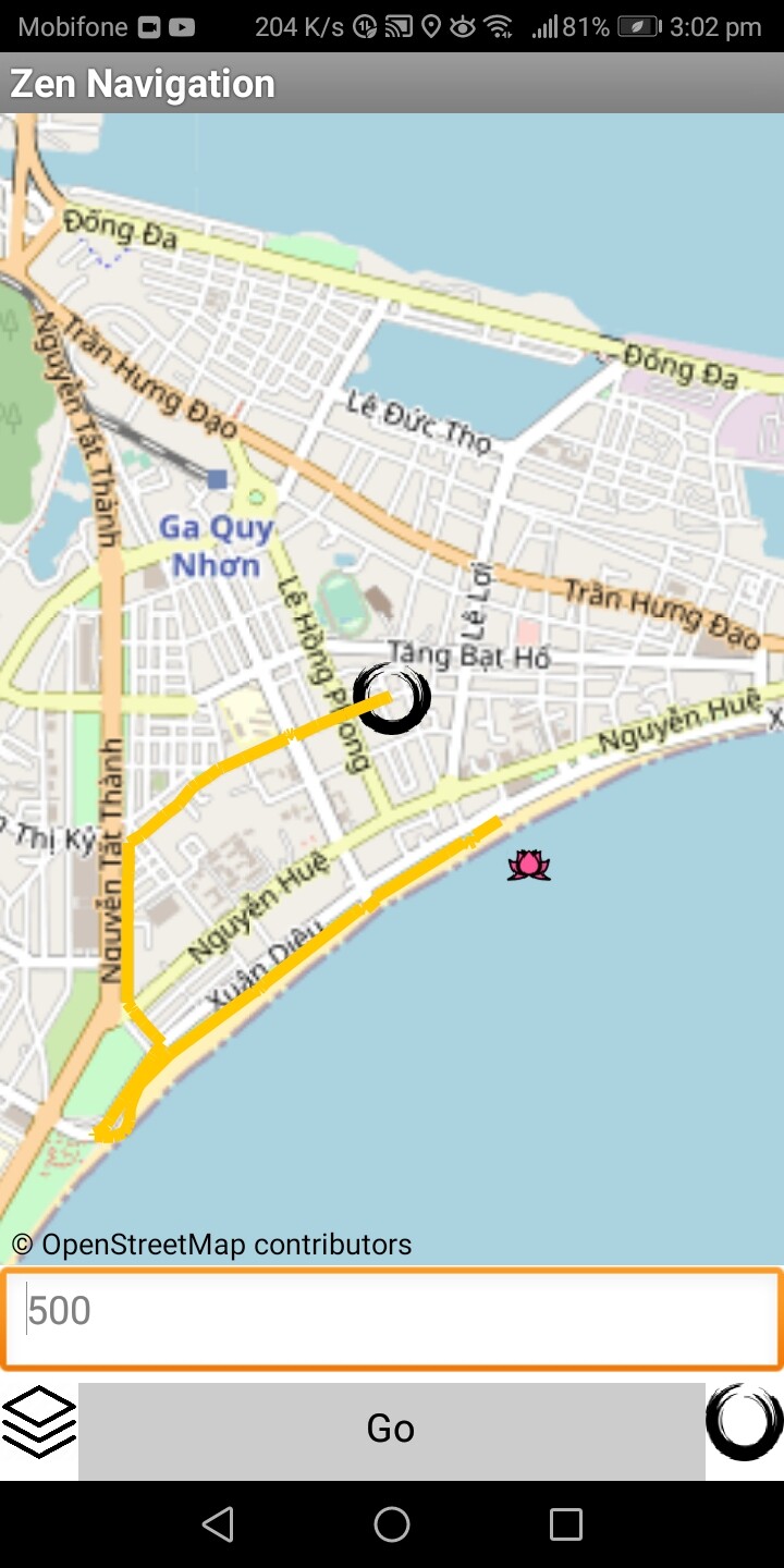
My apologies for the delay in responding. Here’s the result I’m getting. The black circle is the origin at (13.77212, 109.23006), and the destination is actually in the sea (the pink lotus) at (13.7679 109.23132). For the purposes of the app it doesn’t matter that the destination, randomly generated, is not on land. It’s the curious route that is being returned. I have had the same result when the destination is at a similar location, but on land, so it isn’t that the icon is in the sea that is affecting things. I’ve been over the OpenStreetMap in edit and can’t see anything unusual there. The nodes and road type designations seem to be correct. I have changed designations from “assume to not be one way” to “No, not one way”, but it has had no effect.
Hey,
this is indeed a bit tricky and weird.
The point you provided is not on a road of any kind. Since navigation is only done via roads, first a suitable point on any road has to be found.
In this case, this point is on the footway along the beach.
This footway is not connected to any of the other roads where one would expect a connection, but only at this point.
Thus, walking directions have to reach this point first.
If you switch to driving directions, you’ll see that a much more direct approach is being taken.
The point on the road network here can obviously not be on a footway, so a point on the nearby bigger road is chosen.
I assume that the footway along the beach should actually be connected to all the roads where one would assume it is, but since that’s not mapped, it’s not being used for navigation.
Best regards
That makes sense. Thank you. I’ll look into ways of establishing a connection between this footpath and all the roads along the beach front on Open StreetMaps.
2 Likes