Reservoir not geocodable

I’m running a matrix which involves a lake known as “John Redmond Reservoir” in Kansas. The matrix returns 0 zeros for all entries involved in this reservoir. However, an adjacent area known as "
John Redmond Wildlife Area" does register hits. The lake is huge and can be located at 38.237912, -95.804520.

Any ideas why?

Thanks,
GWFAMI

For routing jet skis I believe we have no profile;)

If you’re asking why coordinates inside a lake are not routable for motorized vehicles, bikes or ped, I think the answer is quite obvious. So I must be missing smth. Wanna give a concrete example?

@gwfami2,

If you are using the reverse geocoding:
Search is restricted to 1km around the point.
Try setting boundary.circle.radius to e.g. 5. You will find entries.

The matrix returning 0 is because it can’t find a route connection to that point.
Either because the distance to other points is over the internal routing distance limit for the profile you are using or in your case the point is too far away from a valid point on the street graph.

Still you are talking about geocoding? Are you using the QGIS plugin?

Best regards

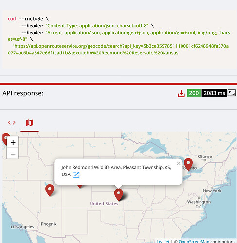
This brings back several locations, none of which is correct.

curl --include
–header “Content-Type: application/json; charset=utf-8”
–header “Accept: application/json, application/geo+json, application/gpx+xml, img/png; charset=utf-8”
https://api.openrouteservice.org/geocode/search?api_key=5b3ce3597851110001cf6248948fa570a0774ac6b4a547e66f1cad1b&text=John%20Redmond%20Reservoir,%20Kansas

The closest is John Redmond Wildlife Area, Pleasant Township, KS, USA, but, this is not the lake itself.

I’m using the QGIS plugin and it doesn’t have any issues with any other lakes. I pulled out the lat/long that is on the layer and tried that using a curl, but it returns a null for the lake.

curl -X POST \
  'https://api.openrouteservice.org/v2/matrix/driving-car' \
  -H 'Content-Type: application/json; charset=utf-8' \
  -H 'Accept: application/json, application/geo+json, application/gpx+xml, img/png; charset=utf-8' \
  -H 'Authorization: 5b3ce3597851110001cf6248948fa570a0774ac6b4a547e66f1cad1b' \
  -d '{"locations":[[-95.8028004,38.2514592],[-95.6925585,38.2268574]],"metrics":["distance"],"units":"mi"}'

Here are the results of the above curl

{“distances”:[[null,null],[null,0.0]],“destinations”:[null,{“location”:[-95.689259,38.234193],“snapped_distance”:865.08}],“sources”:[null,{“location”:[-95.689259,38.234193],“snapped_distance”:865.08}],“metadata”:{“attribution”:“openrouteservice.org | OpenStreetMap contributors”,“service”:“matrix”,“timestamp”:1595716047984,“query”:{“locations”:[[-95.8028004,38.2514592],[-95.6925585,38.2268574]],“profile”:“driving-car”,“responseType”:“json”,“metricsStrings”:[“DISTANCE”],“metrics”:[“distance”],“units”:“mi”},“engine”:{“version”:“6.1.1”,“build_date”:“2020-06-18T15:14:48Z”,“graph_date”:“2020-07-09T23:57:11Z”}}}