Hello,
I did this query for the developers of Qgis, but I was told to ask here questions about ORS.
I am working on a university project based on the use of funiculars and elevators to create routes for people with mobility problems, such as a wheelchair user. To implement well the funiculars I am using a data layer of Open Street Maps, for the routes I am using ORS tools, but I would like to know if this can be done, open route service offers the functionality of routes for people in wheelchairs, but the elevators are not used in the routes because they are not well implemented.I’ve also seen an OSM tools video that shows all the possible routes from one point to another.
I’ve seen some video tutorials for QGIS but they are deprecated, they use the OSM tools plugin which is now called ORS tools and they change a lot of things. If anyone can help me, I’d be very grateful.
Hi,
what I forgot to ask you was to be a little clearer where exactly you need help ![]()
To implement well the funiculars I am using a data layer of Open Street Maps, for the routes I am using ORS tools, but I would like to know if this can be done, open route service offers the functionality of routes for people in wheelchairs, but the elevators are not used in the routes because they are not well implemented
I think this is the relevant paragraph. In the shortest way possible, please describe the workflow you’re imagining and the data sources (with a few examples ideally, like links to OSM IDs). Then we can see how/if we can help.
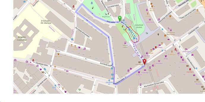
I’ll try to explain my idea better, I’m trying to use a funicular within a route, as you can see in the photo, the route does not use the funicular, the OSM data layer is set as a way, but the creator of routes does not use it, I do not know if it is because it is wrongly implemented. Then I would like to use the ORS functionality to create routes for people in wheelchairs, using the corresponding tag. I’m sorry if I’ve explained myself badly, but I speak another language and may have made mistakes explaining.
In the image I have surrounded with red where the funicular is, and the blue discontinuous line is the route that should be created using the funicular.
Thank you for answering.
Ok, thanks for better explanation, you definitely brought your point across.
Can you please give us a URL for this very furnicular object from https://openstreetmap.org? Smth like https://www.openstreetmap.org/way/41992512, where the number is the OSM ID of the furnicular.
Then we can have a look. Not sure if furniculars are considered in any profile right now, but we’ll check and can maybe add them.
Also, the wheelchair profile is generally only active in Europe, not world-wide. So, if this is not Spain, but Latin America, it won’t work unfortunately.
Thank you!
the problem I think could be found in that they are elevators, and for OSM elevators are used to travel vertically, not as a funicular that takes you to another point of another way
the URLs of the elevator nodes are these:
I am from spain, so the wheelchair service is functional here, more specifically in the Basque country.
Anyway, thank you very much for your interest, it has cost me a lot to find a developer, I have asked in several forums in my country and here are not developed this type of functionality. And passing the university degree depends on this research project, so thank you very much.
It shouldn’t matter that there is an elevator, our code doesn’t check that. As long as the funicular is connected to the road network we could potentially use it for foot-* profiles. And if they’re tagged with wheelchair=yes (because there’s elevators), we could also include them in wheelchair profile.
You can keep track of the progress on this here:
Sorry for not answering before, I’ve been trying to make tests to create the route I want, for that I’ve been using JOSM to create the road that would have to be used, but by introducing it into QGIS with the Quick OSM plugin, the ORS Tools plugin does not use the road I created, I have made tests creating a highway=footway and highway=residential, but ORS Tools does not recognize new roads or use them for routes.
I don’t know what I’m doing wrong, I didn’t want to modify the OSM data layer, that’s why I tried the tests with the data layer I created through JOSM.
I didn’t know if the problem was that I was creating the wrong way, I created a way apart from all the highways and ORS tools didn’t create a route from the beginning of the way to the end.
You may have noticed that I’m new to this whole thing, so I try not to upload the changes to OSM to avoid some disaster because of me, but should I upload the changes to be able to use ORS Tools on the road I created?
Hey,
follow my answer here:
This approach would avoid updating OSM and only do it locally. ORS Tools is querying our online API. Which obviously doesn’t change when you create OSM data locally. So, try to do the setup I’m outlining. It’s pretty involved if you’re not very techie, but all the right keywords are in there to google the required steps.
Good luck!
concerning the funiculars itself: We will not use them in ors any time soon as they represent public transport, which results in multi-modal routing which we have no proper support for.
If you really need this functionality, try setting ORS up locally and run the server from your own compiled sources. In those, you can adapt “WheelchairFlagEncoder.java”, e.g. add
fullyWheelchairAccessibleHighways.add(“funicular”);
or something along those lines.
Cheers
