I am using the directions API and using a walk profile to retrieve directions. I was wondering if its possible to get the street names along with the instructions? For example, right now it only returns instructions like “Turn right” or “Turn left”, but it doesn’t mention the street name. When using the driving profile, the street name is given, but not when walking, which makes it difficult to know where to turn? I am trying to use the instructions as readable directions instead of using them on a map directly, which makes it hard to understand where to actually turn.
Hi @wfar,
if there is a street name for the way you are walking on, it should be displayed if you request instructions.
On foot there are however some “ways” that don’t have names e.g. street crossings (see below), or e.g. paths in the forest.
In that case nothing is displayed.
But if you have a specific example where there should be a name, it can also be a data issue or a bug in ORS.
Could you provide a request & response for your issue?
Best regards
Thanks for getting back to me @amandus.
Unfortunately, that is not the case. I am expecting the street names to at least be shown when making a turn on a major street, but that is not what is returned. All I am getting back are the actual turn instructions but not on which street.
For example, here are the 2 start and end addresses that I am trying to get directions from:
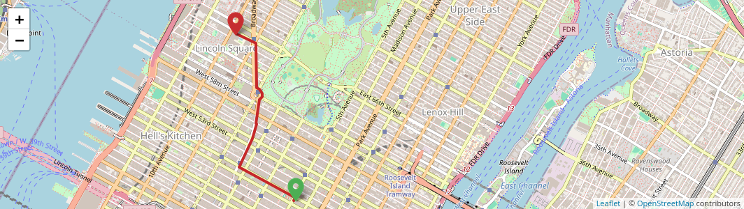
Start: -73.977075, 40.758075 (611 5th Avenue, New York City, NY 10022, USA)
End: -73.984403, 40.773501 (150 West 65th Street, New York City, NY 10023, USA)
I am successfully getting the directions back and the map is correct. Here is the route drawn on the API map in the UI client. But the instructions still don’t have street names on them.
I’ve tried getting results back from both the GET v2/directions/{profile} and the POST /v2/directions/{profile} endpoints but the result is the same.
Here are the geojson returned from the API calls for both.
POST
{
  "bbox": [
    -73.984223,
    40.758173,
    -73.977116,
    40.773742
  ],
  "routes": [
    {
      "summary": {
        "distance": 2276.4,
        "duration": 1639
      },
      "segments": [
        {
          "distance": 2276.4,
          "duration": 1639,
          "steps": [
            {
              "distance": 32.9,
              "duration": 23.7,
              "type": 11,
              "instruction": "Head northeast",
              "name": "-",
              "way_points": [
                0,
                1
              ]
            },
            {
              "distance": 661,
              "duration": 475.9,
              "type": 0,
              "instruction": "Turn left",
              "name": "-",
              "way_points": [
                1,
                17
              ]
            },
            {
              "distance": 418.5,
              "duration": 301.3,
              "type": 1,
              "instruction": "Turn right",
              "name": "-",
              "way_points": [
                17,
                38
              ]
            },
            {
              "distance": 65.4,
              "duration": 47.1,
              "type": 4,
              "instruction": "Turn slight left",
              "name": "-",
              "way_points": [
                38,
                39
              ]
            },
            {
              "distance": 254.2,
              "duration": 183,
              "type": 4,
              "instruction": "Turn slight left",
              "name": "-",
              "way_points": [
                39,
                53
              ]
            },
            {
              "distance": 117.3,
              "duration": 84.4,
              "type": 1,
              "instruction": "Turn right",
              "name": "-",
              "way_points": [
                53,
                71
              ]
            },
            {
              "distance": 40.4,
              "duration": 29.1,
              "type": 0,
              "instruction": "Turn left",
              "name": "-",
              "way_points": [
                71,
                77
              ]
            },
            {
              "distance": 99.1,
              "duration": 71.4,
              "type": 1,
              "instruction": "Turn right",
              "name": "-",
              "way_points": [
                77,
                83
              ]
            },
            {
              "distance": 2.9,
              "duration": 2.1,
              "type": 4,
              "instruction": "Turn slight left",
              "name": "-",
              "way_points": [
                83,
                84
              ]
            },
            {
              "distance": 365,
              "duration": 262.8,
              "type": 13,
              "instruction": "Keep right",
              "name": "-",
              "way_points": [
                84,
                104
              ]
            },
            {
              "distance": 44.4,
              "duration": 32,
              "type": 0,
              "instruction": "Turn left",
              "name": "-",
              "way_points": [
                104,
                113
              ]
            },
            {
              "distance": 125.4,
              "duration": 90.3,
              "type": 12,
              "instruction": "Keep left",
              "name": "-",
              "way_points": [
                113,
                115
              ]
            },
            {
              "distance": 5.2,
              "duration": 3.7,
              "type": 0,
              "instruction": "Turn left",
              "name": "-",
              "way_points": [
                115,
                116
              ]
            },
            {
              "distance": 44.7,
              "duration": 32.2,
              "type": 1,
              "instruction": "Turn right",
              "name": "-",
              "way_points": [
                116,
                119
              ]
            },
            {
              "distance": 0,
              "duration": 0,
              "type": 10,
              "instruction": "Arrive at your destination, on the left",
              "name": "-",
              "way_points": [
                119,
                119
              ]
            }
          ]
        }
      ],
      "bbox": [
        -73.984223,
        40.758173,
        -73.977116,
        40.773742
      ],
      "geometry": "qqwwFduobMs@e@KXIV]hA]|@[jAGRCHCJqCrIIXKZmCpIkAnDITK\\k@hBKGKGeBaAMIMGgBeAIEKEmBy@IEOKkBy@?AICGCECuBa@C?KCGEACqBe@GBEAOEA?}BUSCQEE?}BUC?KAIAAA_BOAGQYAAEGECCAAAECGEA?CAMAU?SBWJ]^CBEAADENELCHAFM^KBO?Y@y@?M@s@?CDK?I?E?eC?E?G?I?E?u@AoADC?K?KAC?cCBE@I?K?A?gC?CNEJ?BEJADAFCLEPCDyApESp@FDGPOf@M`@",
      "way_points": [
        0,
        119
      ]
    }
  ],
  "metadata": {
    "attribution": "openrouteservice.org | OpenStreetMap contributors",
    "service": "routing",
    "timestamp": 1751769560863,
    "query": {
      "coordinates": [
        [
          -73.977075,
          40.758075
        ],
        [
          -73.984403,
          40.773501
        ]
      ],
      "profile": "foot-walking",
      "profileName": "foot-walking",
      "format": "json"
    },
    "engine": {
      "version": "9.3.0",
      "build_date": "2025-06-06T15:39:25Z",
      "graph_date": "2025-06-24T15:58:53Z",
      "osm_date": "1970-01-01T00:00:00Z"
    }
  }
}
GET
{
"type": "FeatureCollection",
"bbox": [
-73.984223,
40.758173,
-73.977116,
40.773742
],
"features": [
{
"bbox": [
-73.984223,
40.758173,
-73.977116,
40.773742
],
"type": "Feature",
"properties": {
"segments": [
{
"distance": 2276.4,
"duration": 1639,
"steps": [
{
"distance": 32.9,
"duration": 23.7,
"type": 11,
"instruction": "Head northeast",
"name": "-",
"way_points": [
0,
1
]
},
{
"distance": 661,
"duration": 475.9,
"type": 0,
"instruction": "Turn left",
"name": "-",
"way_points": [
1,
17
]
},
{
"distance": 418.5,
"duration": 301.3,
"type": 1,
"instruction": "Turn right",
"name": "-",
"way_points": [
17,
38
]
},
{
"distance": 65.4,
"duration": 47.1,
"type": 4,
"instruction": "Turn slight left",
"name": "-",
"way_points": [
38,
39
]
},
{
"distance": 254.2,
"duration": 183,
"type": 4,
"instruction": "Turn slight left",
"name": "-",
"way_points": [
39,
53
]
},
{
"distance": 117.3,
"duration": 84.4,
"type": 1,
"instruction": "Turn right",
"name": "-",
"way_points": [
53,
71
]
},
{
"distance": 40.4,
"duration": 29.1,
"type": 0,
"instruction": "Turn left",
"name": "-",
"way_points": [
71,
77
]
},
{
"distance": 99.1,
"duration": 71.4,
"type": 1,
"instruction": "Turn right",
"name": "-",
"way_points": [
77,
83
]
},
{
"distance": 2.9,
"duration": 2.1,
"type": 4,
"instruction": "Turn slight left",
"name": "-",
"way_points": [
83,
84
]
},
{
"distance": 365,
"duration": 262.8,
"type": 13,
"instruction": "Keep right",
"name": "-",
"way_points": [
84,
104
]
},
{
"distance": 44.4,
"duration": 32,
"type": 0,
"instruction": "Turn left",
"name": "-",
"way_points": [
104,
113
]
},
{
"distance": 125.4,
"duration": 90.3,
"type": 12,
"instruction": "Keep left",
"name": "-",
"way_points": [
113,
115
]
},
{
"distance": 5.2,
"duration": 3.7,
"type": 0,
"instruction": "Turn left",
"name": "-",
"way_points": [
115,
116
]
},
{
"distance": 44.7,
"duration": 32.2,
"type": 1,
"instruction": "Turn right",
"name": "-",
"way_points": [
116,
119
]
},
{
"distance": 0,
"duration": 0,
"type": 10,
"instruction": "Arrive at your destination, on the left",
"name": "-",
"way_points": [
119,
119
]
}
]
}
],
"way_points": [
0,
119
],
"summary": {
"distance": 2276.4,
"duration": 1639
}
},
"geometry": {
"coordinates": [
[
-73.977307,
40.758173
],
[
-73.977116,
40.758432
],
[
-73.97725,
40.758486
],
[
-73.977372,
40.758536
],
[
-73.977737,
40.758695
],
[
-73.978054,
40.758836
],
[
-73.978434,
40.758982
],
[
-73.978526,
40.759017
],
[
-73.978584,
40.75904
],
[
-73.978643,
40.759062
],
[
-73.980335,
40.759788
],
[
-73.980466,
40.759844
],
[
-73.980607,
40.759905
],
[
-73.9823,
40.760606
],
[
-73.983182,
40.760988
],
[
-73.983293,
40.761036
],
[
-73.983438,
40.761098
],
[
-73.983974,
40.76132
],
[
-73.983932,
40.761382
],
[
-73.983891,
40.761441
],
[
-73.983556,
40.76195
],
[
-73.983514,
40.762017
],
[
-73.98347,
40.762088
],
[
-73.98312,
40.762608
],
[
-73.983094,
40.762658
],
[
-73.983059,
40.76272
],
[
-73.982766,
40.763268
],
[
-73.982735,
40.763317
],
[
-73.982682,
40.763402
],
[
-73.98239,
40.763935
],
[
-73.982384,
40.763945
],
[
-73.982361,
40.763986
],
[
-73.982336,
40.764032
],
[
-73.982324,
40.764056
],
[
-73.982155,
40.764646
],
[
-73.982148,
40.764666
],
[
-73.982126,
40.764729
],
[
-73.982102,
40.764768
],
[
-73.98208,
40.764781
],
[
-73.98189,
40.765352
],
[
-73.981914,
40.765387
],
[
-73.981904,
40.765416
],
[
-73.981875,
40.765496
],
[
-73.981872,
40.765509
],
[
-73.981755,
40.76614
],
[
-73.981736,
40.766239
],
[
-73.981713,
40.766331
],
[
-73.981707,
40.766364
],
[
-73.981603,
40.766994
],
[
-73.9816,
40.767011
],
[
-73.981588,
40.76707
],
[
-73.981577,
40.767117
],
[
-73.981574,
40.767129
],
[
-73.981485,
40.767609
],
[
-73.981445,
40.767623
],
[
-73.981315,
40.767708
],
[
-73.981305,
40.767718
],
[
-73.981274,
40.767753
],
[
-73.981249,
40.767782
],
[
-73.981238,
40.767796
],
[
-73.981225,
40.767812
],
[
-73.981208,
40.76784
],
[
-73.981182,
40.767881
],
[
-73.981179,
40.767888
],
[
-73.981173,
40.767906
],
[
-73.981165,
40.767984
],
[
-73.981161,
40.768094
],
[
-73.981181,
40.768191
],
[
-73.981238,
40.768315
],
[
-73.981396,
40.76846
],
[
-73.981419,
40.768483
],
[
-73.981414,
40.768513
],
[
-73.98144,
40.768523
],
[
-73.981518,
40.768553
],
[
-73.98159,
40.76858
],
[
-73.981636,
40.768598
],
[
-73.981677,
40.768615
],
[
-73.981839,
40.768682
],
[
-73.98186,
40.768741
],
[
-73.981862,
40.768824
],
[
-73.981867,
40.768954
],
[
-73.981875,
40.769243
],
[
-73.981877,
40.76931
],
[
-73.981884,
40.769571
],
[
-73.981908,
40.76959
],
[
-73.981907,
40.769651
],
[
-73.981906,
40.769703
],
[
-73.981906,
40.769728
],
[
-73.981912,
40.770401
],
[
-73.981912,
40.770425
],
[
-73.981913,
40.770473
],
[
-73.981914,
40.770523
],
[
-73.981913,
40.770554
],
[
-73.981905,
40.770818
],
[
-73.981929,
40.77122
],
[
-73.98193,
40.771245
],
[
-73.981927,
40.771297
],
[
-73.981923,
40.771358
],
[
-73.981924,
40.771385
],
[
-73.981945,
40.77204
],
[
-73.981946,
40.772073
],
[
-73.981947,
40.772118
],
[
-73.981949,
40.772177
],
[
-73.981949,
40.772187
],
[
-73.981952,
40.772872
],
[
-73.982026,
40.772893
],
[
-73.98209,
40.772917
],
[
-73.982107,
40.772925
],
[
-73.982166,
40.772946
],
[
-73.982198,
40.772955
],
[
-73.982243,
40.772968
],
[
-73.982306,
40.772991
],
[
-73.982399,
40.773023
],
[
-73.982429,
40.77304
],
[
-73.983481,
40.773488
],
[
-73.983727,
40.773591
],
[
-73.983757,
40.77355
],
[
-73.983849,
40.773586
],
[
-73.984048,
40.773667
],
[
-73.984223,
40.773742
]
],
"type": "LineString"
}
}
],
"metadata": {
"attribution": "openrouteservice.org | OpenStreetMap contributors",
"service": "routing",
"timestamp": 1751769577072,
"query": {
"coordinates": [
[
-73.977075,
40.758075
],
[
-73.984403,
40.773501
]
],
"profile": "foot-walking",
"profileName": "foot-walking",
"format": "json"
},
"engine": {
"version": "9.3.0",
"build_date": "2025-06-06T15:39:25Z",
"graph_date": "2025-06-24T15:58:53Z",
"osm_date": "1970-01-01T00:00:00Z"
}
}
}
Here is the curl for both the GET and POST endpoints I am using. I’ve replaced the api key value with a place holder.
GET
curl --location 'https://api.openrouteservice.org/v2/directions/foot-walking?api_key=<YOUR-API-KEY-HERE>&start=-73.977075%2C40.758075&end=-73.984403%2C40.773501'
POST
curl --location 'https://api.openrouteservice.org/v2/directions/foot-walking' \
--header 'Authorization: <YOUR-API-KEY-HERE>' \
--header 'Content-Type: application/json' \
--data '{"coordinates":[[-73.977075,40.758075],[-73.984403,40.773501]]}'
Hey,
thanks for the detailed description of your issue ![]()
What is happening here is indeed exactly what @amandus described.
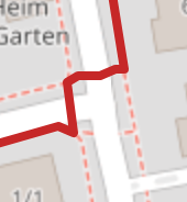
If you look at the details of your route at the corner of 50th and broadway, you can see that routing goes via footways that are mapped separately from the main streets:
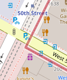
The corresponding ways here are:
and
and as you can see, there are no name=*-tags on the corresponding ways.
The problem here is, that there is nothing linking the road that the sidewalk belongs to (e.g. West 50th Street or Broadway) to the corresponding, separately mapped, “sidewalk” (or footway in this case.)
The corresponding road is correctly tagged with sidewalk=separate, so in this case it would be possible to detect that it should be there, look for a parallel footway and transfer the name from the road to the footway.
I have opened an issue for that: Transfer street name onto parallel sidewalk to improve foot route instructions · Issue #2088 · GIScience/openrouteservice · GitHub
Best regards,
Jakob
2 Likes
Ah gotcha, that makes sense. I was not aware that footways and streets are mapped differently. Out of curiosity, why is it done this way? I can see it why that would be the case in rural locations, but in city or more urban settings, footways will almost always be parralel/attached to the street, right?
Regardless, I appreciate you explaining the situation and opeing the issue. I will keep an eye on it and hopefully see a new feature for this.
In the meantime, do you have an suggestions or workarounds that could provide a better walking routing experience? Is it possible to look up street names using reverse geocoding using coordinates provided from the routing API?
Hey,
there are numerous advantages and disadvantages of mapping sidewalks as separate ways as opposed to mapping them as tags on the corresponding street.
When mapping sidewalks separately, you can add separate information such as surfaces or wayquality, or crossings, curb height, …
You can also denote street furniture (parking spaces, flower pots, …) between the road and the sidewalk.
You are more detailed in the corresponding geometry.
When mapping composed, you only have one geometry, which makes it a lot easier to map, but a lot harder to add the details above.
For more info, have a look at the OSM wiki: Sidewalks - OpenStreetMap Wiki
1 Like
That makes a lot of sense. Appreciate the detailed explanation!
1 Like
2 posts were split to a new topic: Motorway names missing from instructions