Hello, very new to openrouteservice, but familiar with the openstreetmap project. Am trying to understand the service, I was able to create token and generate API key, I went to the API Playground and plugged in coordinates I got from OpenStreetMap.org then click ‘Call Action’. I got the following response:
-{
-“error”: {
“code”:2010,
“message”: “Could not find point 0: 14.4234100 121.0311700 within a radius of 350.0 meters.”
},
-“info”: {
-“engine”: {
“version”: “6.1.1”,
“build_date”:“2020-06-15T14:04:34Z”
},
“timestamp”: 1592646145682}
}
Here are the points 14.42341,121.03117 and 14.43059,121.01534
I did say I was a newbie, but you did not have to be sarcastic about it. It would have been more helpful, if you just explained to me my mistake and correct it. You do know, the answer is not obvious, the error was vague without indicating why the error occurred, this is why I asked for help.
The hint your referring to is in the forums, it might have been logical and helpful to place that piece of information in the API Playground info for other newbies like me.
Also, being the project was using data from OpenStreetMap, it would have been logical to assume that I could just copy and paste coordinates from OpenStreetMap.
I know this is your first post, so this wasn’t the best greeting .
But please be sure to read and search before posting in general.
We try to make sure you encounter information before you have to post.
We put these templates in place and put the lat lon issue as first point exactly because a lot of people are asking about it.
Some people just tend to post without even looking at any documentation or searching the forum which just kind of renders the purpose of a forum useless. If you are not one of them: Sorry again.
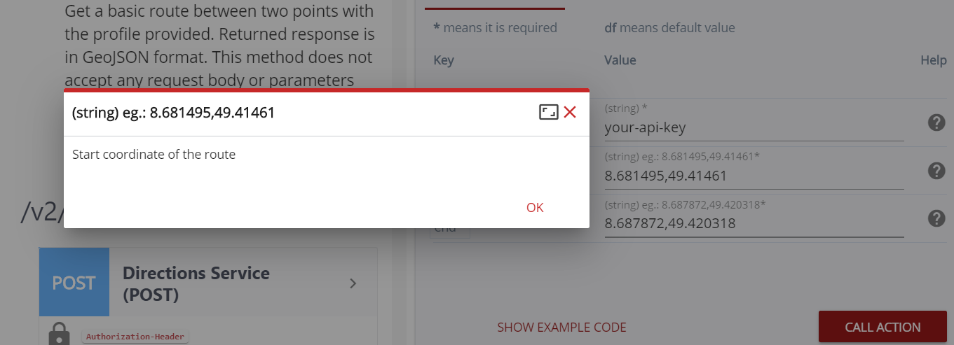
In the defense of the Playground: If you click the ? (Help) Icon for the coordinates parameter, it states the order longitude,latitude as well.
If you want to copy coordinates from a map, try our maps.openrouteservice.org client.
Leftclick on the map and a little popup in the bottom right corner let’s you copy coordinates both ways.
Don’t get it… Who was being sarcastic? If I were you, I’d be happy that someone on a free forum, for a free and open, pretty extensive software, solves your little problem on a Saturday. Humility is a virtue.
Hello, Amandus and Nils, thank you for responding and helping me out. I am not out to pick a fight, (I don’t think we all have time for that) and I am really very grateful that you were able to point me in the right direction. But to be honest, the answer was very obvious for both of you but was not for me. I did try to search in both forum and in the main site, but I just couldn’t find an answer, this was the reason I finally went to the forums to ask.
I honestly did check those ? (Help) but it did not mention longtitude, latitude, maybe someone forgot to place it back on an upgrade (?). I placed an image of the popup being shown as of this minute, maybe it can be corrected.
In any case, thank you both of you, I am still trying to understand, but it is now one step clearer for me.