@jschnell sure!
this is my docker-compose.yml:
# Docker Compose file for the openrouteservice (ORS) application
# Documentation and examples can be found on https://giscience.github.io/openrouteservice/run-instance/running-with-docker
services:
# ----------------- ORS application configuration ------------------- #
ors-app:
# Activate the following lines to build the container from the repository
# You have to add --build to the docker compose command to do so
build:
context: ./
container_name: ors-app
ports:
- "8080:8082" # Expose the ORS API on port 8080
- "9001:9001" # Expose additional port for monitoring (optional)
image: openrouteservice/openrouteservice:v9.0.0
# Advanced option! If you different ids to 0:0 and 1000:1000, you have to rebuild the container with the build args UID,GID.
# The user command is useful if you want easier bind mount access or better security.
#user: "1000:1000" # Run "mkdir -p ors-docker/config ors-docker/elevation_cache ors-docker/files ors-docker/graphs ors-docker/logs && sudo chown -R 1000:1000 ors" before starting the container!
volumes: # Mount relative directories. ONLY for local container runtime. To switch to docker managed volumes see 'Docker Volumes configuration' section below.
- ./ors-docker:/home/ors # Mount the ORS application directory (for logs, graphs, elevation_cache, etc.) into its own directory
#- ./graphs:/home/ors/graphs # Mount graphs directory individually
#- ./elevation_cache:/home/ors/elevation_cache # Mount elevation cache directory individually
#- ./config:/home/ors/config # Mount configuration directory individually
#- ./logs:/home/ors/logs # Mount logs directory individually
#- ./files:/home/ors/files # Mount files directory individually
environment:
REBUILD_GRAPHS: False # Set to True to rebuild graphs on container start.
CONTAINER_LOG_LEVEL: INFO # Log level for the container. Possible values: DEBUG, INFO, WARNING, ERROR, CRITICAL
# If you don't want the default ors-config.yml you can specify a custom file name, that should match the file in
# your 'config' volume mount.
ORS_CONFIG_LOCATION: /home/ors/config/ors-config.yml # Location of your ORS configuration file in the docker container
# ------------------ JAVA OPTS ------------------ #
# Configure the memory settings for JAVA or pass additional opts
# Fore more available ENV properties see Prepare CATALINA_OPTS and JAVA_OPTS
# in https://github.com/GIScience/openrouteservice/blob/main/docker-entrypoint.sh
XMS: 1g # start RAM assigned to java
XMX: 16g # max RAM assigned to java. Rule of Thumb: <PBF-size> * <profiles> * 2
# Example: 1.5 GB pbf size, two profiles (car and foot-walking)
# -> 1.5 * 2 * 2 = 6. Set xmx to be AT LEAST `-Xmx6g`
ADDITIONAL_JAVA_OPTS: "" # further options you want to pass to the java command
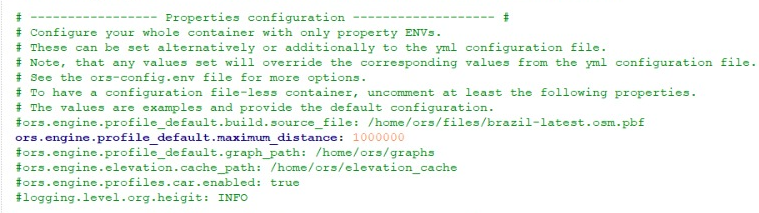
# ----------------- Properties configuration ------------------- #
# Configure your whole container with only property ENVs.
# These can be set alternatively or additionally to the yml configuration file.
# Note, that any values set will override the corresponding values from the yml configuration file.
# See the ors-config.env file for more options.
# To have a configuration file-less container, uncomment at least the following properties.
# The values are examples and provide the default configuration.
ors.endpoints.maximum_range_distance: 1000000
ors.endpoints.isochrones.maximum_range_distance_default: 1000000
#ors.engine.profile_default.build.source_file: /home/ors/files/brazil-latest.osm.pbf
#ors.engine.profile_default.service.maximum_distance: 1000000
#ors.engine.profile_default.graph_path: /home/ors/graphs
#ors.engine.elevation.cache_path: /home/ors/elevation_cache
#ors.engine.profiles.car.enabled: true
#logging.level.org.heigit: INFO
# ----------------- ENV file configuration ------------------- #
# Too many variables for your 'environment:' section?
# Use an env_file with the ENV properties instead and define everything in there:
# Values will be overwritten if set in the 'environment' section.
#env_file: ors-config.env
# ----------------- Healthcheck configuration ------------------- #
# The healthcheck is disabled by default. Uncomment the following lines to enable it.
# The healthcheck allows you to monitor the status of the ORS application.
# Be careful with long graph builds, as the healthcheck will fail and show 'unhealthy' during this time.
# This is especially useful if you run your ORS container in a production environment.
#healthcheck:
# test: wget --no-verbose --tries=1 --spider http://localhost:8082/ors/v2/health || exit 1
# start_period: 1m
# interval: 10s
# timeout: 2s
# retries: 3
# disable: false
# ----------------- Docker Volumes configuration ------------------- #
# Define the Docker managed volumes for the ORS application. For more info on Docker Volumes see https://docs.docker.com/compose/compose-file/07-volumes/
# Volumes are used to persist the data and configuration of the ORS application.
# If you want to use volumes, uncomment the following lines and remove the ./ prefix from the volume paths in 'services.ors-app.volumes'.
#volumes:
# graphs:
# elevation_cache:
# config:
# logs:
# files:
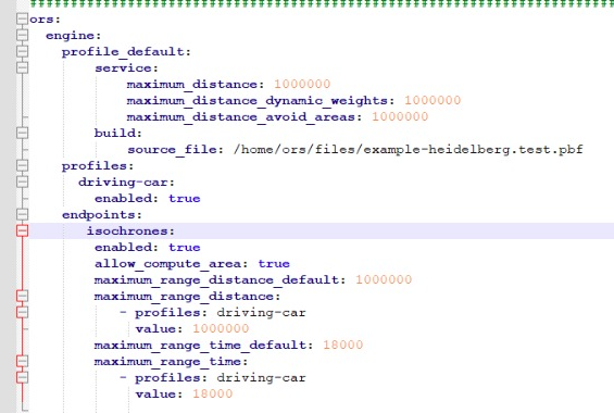
This is my ors-config.yml:
################################################################################################
### Minimal configuration example file for openrouteservice. For a description please visit: ###
### https://giscience.github.io/openrouteservice/run-instance/configuration/                 ###
################################################################################################
ors:
  engine:
    profile_default:
        service:
            maximum_distance: 1000000
            maximum_distance_dynamic_weights: 1000000
            maximum_distance_avoid_areas: 1000000
        build:
            source_file: /home/ors/files/example-heidelberg.test.pbf
    profiles:
      driving-car:
        enabled: true
    endpoints:
       isochrones:
        enabled: true
        allow_compute_area: true
        maximum_range_distance_default: 1000000
        maximum_range_distance:
           - profiles: driving-car
             value: 1000000
        maximum_range_time_default: 18000
        maximum_range_time:
           - profiles: driv
################################################################################
### Configuration file for openrouteservice. For a description please visit: ###
### https://giscience.github.io/openrouteservice/run-instance/configuration/ ###
################################################################################
##### General server settings #####
#server:
#  port: 8082
#  error:
#    whitelabel:
#      enabled: false
#  # Keep the context-path at / else the war file run with tomcat will have the context-path of /ors/v2 as well.
#  servlet:
#    context-path: /ors
#  tomcat:
#    keep-alive-timeout: 30000
#spring:
#  profiles:
#    active: default
#  mvc:
#    servlet:
#      path: /
##### Settings related to springdoc #####
#springdoc:
#  swagger-ui:
#    enabled: true
#    path: /swagger-ui
#    tryItOutEnabled: true
#    filter: false
#    syntaxHighlight:
#      activated: true
#    showExtensions: true
#  api-docs:
#    path: /v2/api-docs
#    version: OPENAPI_3_0
#  packages-to-scan: org.heigit.ors
#  pathsToMatch: /v2/**
##### Logging settings #####
#logging:
#  file:
#    name: ./logs/ors.log
#  pattern:
#    console: "%d{yyyy-MM-dd HH:mm:ss} %highlight{%-7p} %style{%50t}{Cyan} %style{[ %-40.40c{1.} ]}{Bright Cyan}   %m%n"
#    file: "%d{yyyy-MM-dd HH:mm:ss} %p [%-40.40c{1.}] - %m%n"
#  level:
#    root: WARN
#    org.heigit: INFO
##### openrouteservice specific settings #####
#ors:
#  cors:
#    allowed_origins: "*"
#    allowed_headers: Content-Type, X-Requested-With, accept, Origin, Access-Control-Request-Method, Access-Control-Request-Headers, Authorization
#    preflight_max_age: 600
#  messages:
#  ##### ORS endpoints settings #####
#  endpoints:
#    routing:
#      enabled: true
#      attribution: openrouteservice.org, OpenStreetMap contributors, tmc - BASt
#      gpx_name: ORSRouting
#      gpx_description: This is a directions instructions file as GPX, generated from openrouteservice
#      gpx_base_url: https://openrouteservice.org/
#      gpx_support_mail: support@openrouteservice.org
#      gpx_author: openrouteservice
#      gpx_content_licence: LGPL 3.0
#      maximum_avoid_polygon_area: 200000000
#      maximum_avoid_polygon_extent: 20000
#      maximum_alternative_routes: 3
#    matrix:
#      enabled: true
#      attribution: openrouteservice.org, OpenStreetMap contributors
#      maximum_routes: 2500
#      maximum_routes_flexible: 25
#      maximum_visited_nodes: 100000
#      maximum_search_radius: 2000
#      u_turn_costs: -1
#    isochrones:
#      enabled: true
#      attribution: openrouteservice.org, OpenStreetMap contributors
#      maximum_locations: 2
#      maximum_intervals: 1
#      allow_compute_area: true
#      maximum_range_distance_default: 50000
#      maximum_range_distance:
#        - profiles: driving-car, driving-hgv
#          value: 100000
#      maximum_range_time_default: 18000
#      maximum_range_time:
#        - profiles: driving-car, driving-hgv
#          value: 3600
#      fastisochrones:
#        maximum_range_distance_default: 50000
#        maximum_range_distance:
#          - profiles: driving-car, driving-hgv
#            value: 500000
#        maximum_range_time_default: 18000
#        maximum_range_time:
#          - profiles: driving-car, driving-hgv
#            value: 10800
#    snap:
#      enabled: true
#      attribution: openrouteservice.org, OpenStreetMap contributors
#      maximum_locations: 5000
#  ##### ORS engine settings #####
#  engine:
#    init_threads: 1
#    preparation_mode: false
#    graphs_data_access: RAM_STORE
#    elevation:
#      preprocessed: false
#      data_access: MMAP
#      cache_clear: false
#      provider: multi
#      cache_path: elevation_cache
#    profile_default:
#      enabled: false
#      graph_path: graphs
#      build:
#        source_file:
#        elevation: true
#        elevation_smoothing: false
#        encoder_flags_size: 8
#        instructions: true
#        optimize: false
#        traffic: false
#        maximum_speed_lower_bound: 80
#        location_index_resolution: 500
#        location_index_search_iterations: 4
#        interpolate_bridges_and_tunnels: true
#        preparation:
#          min_network_size: 200
#          methods:
#            lm:
#              enabled: true
#              threads: 1
#              weightings: recommended,shortest
#              landmarks: 16
#      service:
#        maximum_distance: 100000
#        maximum_distance_dynamic_weights: 100000
#        maximum_distance_avoid_areas: 100000
#        maximum_waypoints: 50
#        maximum_snapping_radius: 400
#        maximum_distance_alternative_routes: 100000
#        maximum_distance_round_trip_routes: 100000
#        maximum_visited_nodes: 1000000
#        force_turn_costs: false
#        execution:
#          methods:
#            lm:
#              active_landmarks: 8
#    ##### Profile specific settings,                               #####
#    ##### overriding the properties in ors.engine.profile_default. #####
#    ##### Profile defaults defined here are not overridden by      #####
#    ##### a custom YAML file's ors.engine.profile_default, but by  #####
#    ##### a custom YAML file's ors.engine.profiles.<profile>       #####
#    profiles:
#      driving-car:
#        encoder_name: driving-car
#        build:
#          encoder_options:
#            turn_costs: true
#            block_fords: false
#            use_acceleration: true
#          preparation:
#            min_network_size: 200
#            methods:
#              ch:
#                enabled: true
#                threads: 1
#                weightings: fastest
#              lm:
#                enabled: false
#              core:
#                enabled: true
#                threads: 1
#                weightings: fastest,shortest
#                landmarks: 64
#                lmsets: highways;allow_all
#          ext_storages:
#            WayCategory:
#            HeavyVehicle:
#            Tollways:
#            WaySurfaceType:
#            RoadAccessRestrictions:
#              use_for_warnings: true
#        service:
#          execution:
#            methods:
#              lm:
#                active_landmarks: 6
#              core:
#                active_landmarks: 6
#      driving-hgv:
#        encoder_name: driving-hgv
#        build:
#          encoder_options:
#            turn_costs: true
#            block_fords: false
#            use_acceleration: true
#          preparation:
#            min_network_size: 200
#            methods:
#              ch:
#                enabled: true
#                threads: 1
#                weightings: recommended
#              lm:
#                enabled: false
#              core:
#                enabled: true
#                threads: 1
#                weightings: recommended,shortest
#                landmarks: 64
#                lmsets: highways;allow_all
#          ext_storages:
#            WayCategory:
#            HeavyVehicle:
#              restrictions: true
#            Tollways:
#            WaySurfaceType:
#        service:
#          execution:
#            methods:
#              core:
#                active_landmarks: 6
#      cycling-regular:
#        encoder_name: cycling-regular
#        build:
#          encoder_options:
#            consider_elevation: true
#            turn_costs: true
#            block_fords: false
#          ext_storages:
#            WayCategory:
#            WaySurfaceType:
#            HillIndex:
#            TrailDifficulty:
#      cycling-mountain:
#        encoder_name: cycling-mountain
#        build:
#          encoder_options:
#            consider_elevation: true
#            turn_costs: true
#            block_fords: false
#          ext_storages:
#            WayCategory:
#            WaySurfaceType:
#            HillIndex:
#            TrailDifficulty:
#      cycling-road:
#        encoder_name: cycling-road
#        build:
#          encoder_options:
#            consider_elevation: true
#            turn_costs: true
#            block_fords: false
#          ext_storages:
#            WayCategory:
#            WaySurfaceType:
#            HillIndex:
#            TrailDifficulty:
#      cycling-electric:
#        encoder_name: cycling-electric
#        build:
#          encoder_options:
#            consider_elevation: true
#            turn_costs: true
#            block_fords: false
#          ext_storages:
#            WayCategory:
#            WaySurfaceType:
#            HillIndex:
#            TrailDifficulty:
#      foot-walking:
#        encoder_name: foot-walking
#        build:
#          encoder_options:
#            block_fords: false
#          ext_storages:
#            WayCategory:
#            WaySurfaceType:
#            HillIndex:
#            TrailDifficulty:
#      foot-hiking:
#        encoder_name: foot-hiking
#        build:
#          encoder_options:
#            block_fords: false
#          ext_storages:
#            WayCategory:
#            WaySurfaceType:
#            HillIndex:
#            TrailDifficulty:
#      wheelchair:
#        encoder_name: wheelchair
#        build:
#          encoder_options:
#            block_fords: true
#          ext_storages:
#            WayCategory:
#            WaySurfaceType:
#            Wheelchair:
#              kerbs_on_crossings: true
#            OsmId:
#        service:
#          maximum_snapping_radius: 50
#      public-transport:
#        encoder_name: public-transport
#        build:
#          encoder_options:
#            block_fords: false
#          elevation: true
#          gtfs_file: ./src/test/files/vrn_gtfs_cut.zip
#        service:
#          maximum_visited_nodes: 1000000