Hi,
we are trying to get the isochrones starting from a fire station.
We ran into the issue that the isochrone for cars/trucks is way too small (even smaller than with a bicycle sometimes) as it doesn’t calculate the speed correctly.
Edit:
Isochrone example: 5 Minute Isochrone around Rennweg 1, 91126 Rednitzhembach (49.2987, 11.06904)
15km/h example: Route from Rennweg 1 to Rother Straße 5 in 91126 Rednitzhembach (49.30270,11.07903)
The average speed of a 2 km stretch is like ~15km/h when the speed limit on those roads would be 30km/h. This seems to be the case as the roads in question did not have any tags other than residential.
Now given that we need this information for fire engines the speed limit does not apply in the same way. Instead we have average values that apply on residential roads (40-60km/h) and outside of town (~60km/h).
Is there a way to overwrite all the speed limits and use our values instead?
Preferably we would also enjoy the use of the max_speed of a vehicle on highways but for now the overwrite is more important.
Thank you for your help ![]()
Edit 2:
I guess I should have added the word ‘emergency’ to the search. There are a few threads about it already. Before I delete this one I will try out the solutions in the other posts, as I am not sure how the supposed scaling will affect my results. If the scaling is working like ‘2x all speed limits’ I don’t think it will solve the issue.
Edit 1:
Unfortunately I can’t add more than 2 links so I added the coordinates instead.
The plan is to run ORS locally.
The isochrones are with 5 minutes driving time, so I could use the distance that can be reached with my average speeds and generate the ‘isochrone’ for every speed. I’d prefer to get an anctual isochrone that does take intersections etc. into account and also accounts for roads with higher speed limits.
I guess im looking for a minimum speed limit that gets used as long as no higher limits are in place.`
This is some general stuff I found out so far:
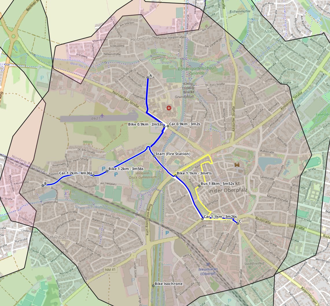
As the bike isochrone is sometimes larger than the car isochrone I chose a point (B) close to the edge of the cars isochrone. Comparing the route revealed that the bike is faster than the car by 40s even though they both take the same route. This route seems to have the same conditions for both cars and bikes.
Route on ORS: Start to B
Point A was chosen to check if bike paths make a difference and they do. Still the car is slower than the bike.
Route: Sankt-Florian-Str. 2 92318 Neumarkt (49.28234, 11.45035) to intersection Sankt-Anna-Str. and Dr.-Wehner-Str. 92318 Neumarkt (49.28877, 11.44991)
Point C was me just poking around and finding that large vehicles somehow cannot cross over a street that cars seem to have no issue with. Funnily enough there is actually a bus line that does cross right there.
The issue with this is that the isochrone towards the south-east will be impacted.
Route on ORS: Start to C
Intersection on OSM: 49.28067, 11.45260