Hello, I’m having an issue with the ORS installation.
I’m trying to install the OSR on the WSL, according to the guide at Building from Source | openrouteservice backend documentation , however, when I try to upload the maven service I get the following error:
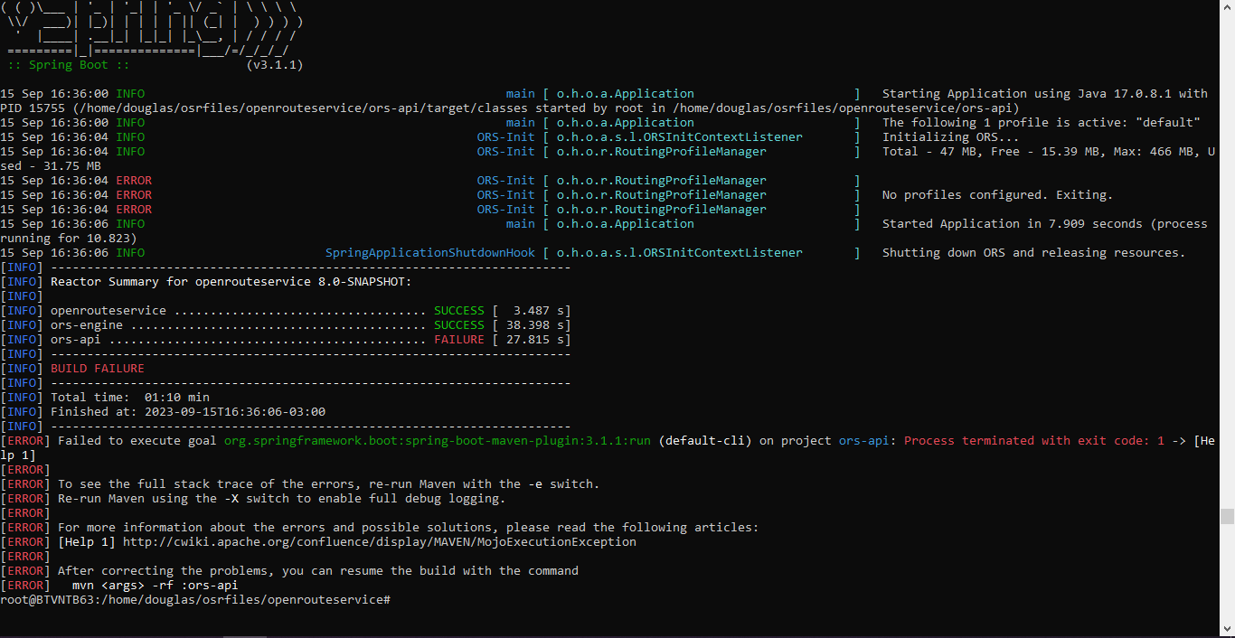
15 Sep 16:36:04 ERROR ORS-Init [ o.h.o.r.RoutingProfileManager ]
I would like to know if there is any configuration I can try to correct the error.
1 Like
cheetah
December 17, 2023, 11:07pm
2
I’m also having this issue! Were you able to get an answer?
1 Like
Jem
February 12, 2024, 5:08pm
3
Also, wondering if there was a resolution to this issue? I am running it in a docker container and previous builds did not experience this but now I am.
datplt
March 12, 2024, 10:43am
4
Try my config file:
spring:
 profiles:
   active: default
 mvc:
   servlet:
     path: /
ors:
  cors:
    allowed_origins: "*"
    allowed_headers: Content-Type, X-Requested-With, accept, Origin,
      Access-Control-Request-Method, Access-Control-Request-Headers,
      Authorization
    preflight_max_age: 600
  endpoints:
    routing:
      enabled: true
      attribution: openrouteservice.org, OpenStreetMap contributors, tmc - BASt
      gpx_name: ORSRouting
      gpx_description: This is a directions instructions file as GPX, generated from openrouteservice
      gpx_base_url: https://openrouteservice.org/
      gpx_support_mail: support@openrouteservice.org
      gpx_author: openrouteservice
      gpx_content_licence: LGPL 3.0
      maximum_avoid_polygon_area: 200000000
      maximum_avoid_polygon_extent: 20000
      maximum_alternative_routes: 3
    matrix:
      enabled: true
      attribution: openrouteservice.org, OpenStreetMap contributors
      maximum_routes: 100
      maximum_routes_flexible: 25
      maximum_visited_nodes: 100000
      maximum_search_radius: 5000
      u_turn_costs: -1
    isochrone:
      enabled: true
      attribution: openrouteservice.org, OpenStreetMap contributors
      maximum_locations: 2
      maximum_intervals: 1
      allow_compute_area: true
      maximum_range_distance_default: 50000
      maximum_range_distance:
        - profiles: driving-car, driving-hgv
          value: 100000
      maximum_range_time_default: 18000
      maximum_range_time:
        - profiles: driving-car, driving-hgv
          value: 3600
      fastisochrones:
        maximum_range_distance_default: 50000
        maximum_range_distance:
          - profiles: driving-car, driving-hgv
            value: 500000
        maximum_range_time_default: 18000
        maximum_range_time:
          - profiles: driving-car, driving-hgv
            value: 10800
    Snap:
      enabled: true
      attribution: openrouteservice.org, OpenStreetMap contributors
  engine:
    source_file:  /home/ors/ors-core/data/osm_file.pbf
    graphs_root_path: /home/ors/ors-core/data/graphs
    elevation:
      cache_path: /home/ors/ors-core/data/elevation_cache
    profiles:
      active:
        enabled: true
        profile: driving-car
        elevation: true
        encoder_options:
          turn_costs: true
          block_fords: false
          use_acceleration: true
        preparation:
          min_network_size: 200
          min_one_way_network_size: 200
          methods:
            ch:
              enabled: true
              threads: 1
              weightings: fastest
            lm:
              enabled: false
              threads: 1
              weightings: fastest,shortest
              landmarks: 16
            core:
              enabled: true
              threads: 1
              weightings: fastest,shortest
              landmarks: 64
              lmsets: highways;allow_all
        execution:
          methods:
            ch:
              disabling_allowed: true
            lm:
              disabling_allowed: true
              active_landmarks: 6
            core:
              disabling_allowed: true
              active_landmarks: 6
        ext_storages:
          WayCategory: null
          HeavyVehicle: null
          WaySurfaceType: null
          RoadAccessRestrictions:
            use_for_warnings: true
      car:
        enabled: true
        profile: driving-car
        elevation: true
        encoder_options:
          turn_costs: true
          block_fords: false
          use_acceleration: true
        preparation:
          min_network_size: 200
          min_one_way_network_size: 200
          methods:
            ch:
              enabled: true
              threads: 1
              weightings: fastest
            lm:
              enabled: false
              threads: 1
              weightings: fastest,shortest
              landmarks: 16
            core:
              enabled: true
              threads: 1
              weightings: fastest,shortest
              landmarks: 64
              lmsets: highways;allow_all
        execution:
          methods:
            ch:
              disabling_allowed: true
            lm:
              disabling_allowed: true
              active_landmarks: 6
            core:
              disabling_allowed: true
              active_landmarks: 6
        ext_storages:
          WayCategory: null
          HeavyVehicle: null
          WaySurfaceType: null
          RoadAccessRestrictions:
            use_for_warnings: true