Hello,
I am facing some problems during installation of ORS instance on my linux server via docker. i am following the instruction mentioned on the official documentation but still not work. I want to build with elevation data for “Cycling-Regular & Foot-Walking” profiles.
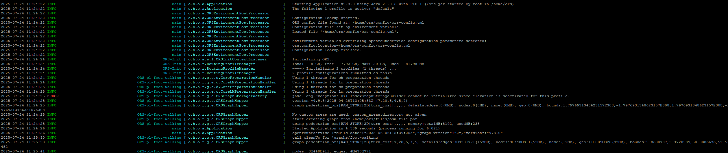
When i try to run “docker compose build up -d” command and check logs it says “java.lang.Exception: HillIndexGraphStorageBuilder cannot be initialized since elevation is deactivated for this profile”
Can you please help me. i need to create ischrones also ahead. My study area needs elevation data.
Here is my ors-config file code
ors:
  engine:
    elevation:
      provider: "raster"
      raster:
        paths:
          - "/home/ors/dem/elevation.tif"
      preprocessed: false
      cache_path: "/home/ors/elevation_cache"
      smoothing: false
    profile_default:
      enabled: false
      build:
        source_file: /home/ors/files/osm_file.pbf
    profiles:
      foot-walking:
        enabled: true
        build:
          elevation: true
      cycling-regular:
        enabled: true
        build:
          elevation: true
and following is my docker-compose file code
services:
  ors-app:
    container_name: ors-app
    image: openrouteservice/openrouteservice:v9.3.0
    ports:
      - "8080:8082"
      - "9001:9001"
    volumes:
      - /mnt/sasraid/ors-nrw/config:/home/ors/config
      - /mnt/sasraid/ors-nrw/elevation_cache:/home/ors/elevation_cache
      - /mnt/sasraid/ors-nrw/dem:/home/ors/dem
      - /mnt/sasraid/ors-nrw/graphs:/home/ors/graphs
      - /mnt/sasraid/ors-nrw/logs:/home/ors/logs
      - /mnt/sasraid/ors-nrw/files/nordrhein-westfalen-latest.osm.pbf:/home/ors/files/osm_file.pbf
    environment:
      ORS_CONFIG_LOCATION: /home/ors/config/ors-config.yml
      REBUILD_GRAPHS: "True"
      XMS: "8g"
      XMX: "20g"
      # ORS_ENGINE_PROFILE_DEFAULT_BUILD_SOURCE_FILE: /home/ors/files/osm_file.pbf
      # ORS_ENGINE_PROFILE_DEFAULT_GRAPH_PATH: /home/ors/graphs
      # ORS_ENGINE_ELEVATION_CACHE_PATH: /home/ors/elevation_cache
      CONTAINER_LOG_LEVEL: "INFO"
I have already checked my elevation data is in “4326 coordinate system” but it is a subset part of OSM pbf dataset.
here is a error image. If some one guide me it would be really helpful.