Directions with avoid_borders all creates error 2099

Hi everyone,

I build a local server with the osm data for south america from Geofabric Geofabrik Download Server.

I used the newest build engine 6.6.3. When I calculate a route and try to avoid all borders with the following request:

  curl -X POST \
  'http://localhost:8080/ors/v2/directions/driving-car/json' \
  -H 'Content-Type: application/json; charset=utf-8' \
  -H 'Accept: application/json, application/geo+json, application/gpx+xml, img/png; charset=utf-8' \
  -d '{"coordinates":[[-80.2785057947195,-3.49888363247019],[-79.97423389332448,-4.426234636183795]],"options":{"avoid_borders":"all"}}'

I receive the following error:

{"error":{"code":2099,"message":"Unable to compute a route"},"info":{"engine":{"version":"6.6.3","build_date":"2021-12-18T21:17:36Z"},"timestamp":16399

The ors log shows the following error:

2021-12-19 17:29:22,946 ERROR [routing.RoutingProfile] - java.lang.NullPointerException

If I do the same without the options everything works fine. The same call against your url https://api.openrouteservice.org/v2/directions/driving-car works fine.

I used the following app conf:

{
  "ors": {
    "info": {
      "base_url": "https://openrouteservice.org/",
      "support_mail": "support@openrouteservice.org",
      "author_tag": "openrouteservice",
      "content_licence": "LGPL 3.0"
    },
    "services": {
      "matrix": {
        "enabled": true,
        "maximum_routes": 1000000,
        "maximum_routes_flexible": 25000,
        "maximum_search_radius": 5000,
        "maximum_visited_nodes": 1000000,
        "allow_resolve_locations": true,
        "attribution": "openrouteservice.org, OpenStreetMap contributors"
      },
      "isochrones": {
        "enabled": true,
        "maximum_range_distance": [
          {
            "profiles": "any",
            "value": 50000
          },
          {
            "profiles": "driving-car, driving-hgv",
            "value": 100000
          }
        ],
        "maximum_range_time": [
          {
            "profiles": "any",
            "value": 18000
          },
          {
            "profiles": "driving-car, driving-hgv",
            "value": 28800
          }
        ],
        "fastisochrones": {
          "maximum_range_distance": [
            {
              "profiles": "any",
              "value": 50000
            },
            {
              "profiles": "driving-car, driving-hgv",
              "value": 500000
            }
          ],
          "maximum_range_time": [
            {
              "profiles": "any",
              "value": 18000
            },
            {
              "profiles": "driving-car, driving-hgv",
              "value": 10800
            }
          ],
          "profiles": {
            "default_params": {
              "enabled": false,
              "threads": 12,
              "weightings": "recommended",
              "maxcellnodes": 5000
            },
            "profile-vehicles-hgv": {
              "enabled": true,
              "threads": 12,
              "weightings": "recommended, shortest",
              "maxcellnodes": 5000
            }
          }
        },
        "maximum_intervals": 10,
        "maximum_locations": 2,
        "allow_compute_area": true
      },
      "routing": {
        "enabled": true,
        "mode": "normal",
        "routing_description": "This is a routing file from openrouteservice",
        "routing_name": "openrouteservice routing",
        "sources": [
          "data/osm_file.pbf"
        ],
        "init_threads": 1,
        "attribution": "openrouteservice.org, OpenStreetMap contributors",
        "elevation_preprocessed": false,
        "profiles": {
          "active": [
            "car",
			"hgv"
          ],
          "default_params": {
            "encoder_flags_size": 8,
            "graphs_root_path": "data/graphs",
            "elevation_provider": "multi",
            "elevation_cache_path": "data/elevation_cache",
            "elevation_cache_clear": false,
            "instructions": true,
            "maximum_distance": 9000000,
            "maximum_distance_dynamic_weights": 9000000,
            "maximum_distance_avoid_areas": 9000000,
            "maximum_waypoints": 50,
            "maximum_snapping_radius": 400,
            "maximum_avoid_polygon_area": 200000000,
            "maximum_avoid_polygon_extent": 20000,
            "maximum_distance_alternative_routes": 9000000,
            "maximum_alternative_routes": 3,
            "maximum_distance_round_trip_routes": 9000000,
            "maximum_speed_lower_bound": 80,
            "preparation": {
              "min_network_size": 200,
              "min_one_way_network_size": 200,
              "methods": {
                "lm": {
                  "enabled": true,
                  "threads": 1,
                  "weightings": "recommended,shortest",
                  "landmarks": 16
                }
              }
            },
            "execution": {
              "methods": {
                "lm": {
                  "disabling_allowed": true,
                  "active_landmarks": 8
                }
              }
            }
          },
          "profile-car": {
            "profiles": "driving-car",
            "parameters": {
              "encoder_flags_size": 8,
              "encoder_options": "turn_costs=true|block_fords=false|use_acceleration=false",
              "maximum_distance": 9000000,
              "elevation": true,
              "maximum_snapping_radius": 350,
              "preparation": {
                "min_network_size": 200,
                "min_one_way_network_size": 200,
                "methods": {
                  "ch": {
                    "enabled": true,
                    "threads": 1,
                    "weightings": "fastest"
                  },
                  "lm": {
                    "enabled": false,
                    "threads": 1,
                    "weightings": "fastest,shortest",
                    "landmarks": 16
                  },
                  "core": {
                    "enabled": true,
                    "threads": 1,
                    "weightings": "fastest,shortest",
                    "landmarks": 64,
                    "lmsets": "highways;allow_all"
                  }
                }
              },
              "execution": {
                "methods": {
                  "ch": {
                    "disabling_allowed": true
                  },
                  "lm": {
                    "disabling_allowed": true,
                    "active_landmarks": 6
                  },
                  "core": {
                    "disabling_allowed": true,
                    "active_landmarks": 6
                  }
                }
              },
              "ext_storages": {
                "WayCategory": {},
                "HeavyVehicle": {},
                "WaySurfaceType": {},
                "RoadAccessRestrictions": {
                  "use_for_warnings": true
                }
              }
            }
          },
          "profile-hgv": {
            "profiles": "driving-hgv",
            "parameters": {
              "encoder_flags_size": 8,
              "encoder_options": "turn_costs=true|block_fords=false|use_acceleration=false",
              "maximum_distance": 9000000,
              "elevation": true,
              "preparation": {
                "min_network_size": 200,
                "min_one_way_network_size": 200,
                "methods": {
                  "ch": {
                    "enabled": true,
                    "threads": 1,
                    "weightings": "recommended"
                  },
                  "lm": {  
                    "enabled": true,
                    "threads": 1,
                    "weightings": "recommended,shortest",
                    "landmarks": 16
                  },
                  "core": {
                    "enabled": true,
                    "threads": 1,
                    "weightings": "recommended,shortest",
                    "landmarks": 64,
                    "lmsets": "highways;allow_all"
                  }
                }
              },
              "execution": {
                "methods": {
                  "ch": {
                    "disabling_allowed": true
                  },
				  "lm": {  
                    "disabling_allowed": true,
                    "active_landmarks": 6
                  },
                  "core": {
                    "disabling_allowed": true,
                    "active_landmarks": 6
                  }
                }
              },
              "ext_storages": {
                "WayCategory": {},
                "HeavyVehicle": {
                  "restrictions": true
                },
                "WaySurfaceType": {}
              }
            }
          },
          "profile-bike-regular": {
            "profiles": "cycling-regular",
            "parameters": {
              "encoder_options": "consider_elevation=true|turn_costs=true|block_fords=false",
              "elevation": true,
              "ext_storages": {
                "WayCategory": {},
                "WaySurfaceType": {},
                "HillIndex": {},
                "TrailDifficulty": {}
              }
            }
          },
          "profile-bike-mountain": {
            "profiles": "cycling-mountain",
            "parameters": {
              "encoder_options": "consider_elevation=true|turn_costs=true|block_fords=false",
              "elevation": true,
              "ext_storages": {
                "WayCategory": {},
                "WaySurfaceType": {},
                "HillIndex": {},
                "TrailDifficulty": {}
              }
            }
          },
          "profile-bike-road": {
            "profiles": "cycling-road",
            "parameters": {
              "encoder_options": "consider_elevation=true|turn_costs=true|block_fords=false",
              "elevation": true,
              "ext_storages": {
                "WayCategory": {},
                "WaySurfaceType": {},
                "HillIndex": {},
                "TrailDifficulty": {}
              }
            }
          },
          "profile-bike-electric": {
            "profiles": "cycling-electric",
            "parameters": {
              "encoder_options": "consider_elevation=true|turn_costs=true|block_fords=false",
              "elevation": true,
              "ext_storages": {
                "WayCategory": {},
                "WaySurfaceType": {},
                "HillIndex": {},
                "TrailDifficulty": {}
              }
            }
          },
          "profile-walking": {
            "profiles": "foot-walking",
            "parameters": {
              "encoder_options": "block_fords=false",
              "elevation": true,
              "ext_storages": {
                "WayCategory": {},
                "WaySurfaceType": {},
                "HillIndex": {},
                "TrailDifficulty": {}
              }
            }
          },
          "profile-hiking": {
            "profiles": "foot-hiking",
            "parameters": {
              "encoder_options": "block_fords=false",
              "elevation": true,
              "ext_storages": {
                "WayCategory": {},
                "WaySurfaceType": {},
                "HillIndex": {},
                "TrailDifficulty": {}
              }
            }
          },
          "profile-wheelchair": {
            "profiles": "wheelchair",
            "parameters": {
              "encoder_options": "block_fords=true",
              "elevation": true,
              "maximum_snapping_radius": 50,
              "ext_storages": {
                "WayCategory": {},
                "WaySurfaceType": {},
                "Wheelchair": {
                  "KerbsOnCrossings": "true"
                },
                "OsmId": {}
              }
            }
          }
        }
      }
    },
    "logging": {
      "enabled": true,
      "level_file": "DEBUG_LOGGING.json",
      "location": "/var/log/ors",
      "stdout": true
    },
    "system_message": [
      {
        "active": false,
        "text": "This message would be sent with every routing bike fastest request",
        "condition": {
          "request_service": "routing",
          "request_profile": "cycling-regular,cycling-mountain,cycling-road,cycling-electric",
          "request_preference": "fastest"
        }
      },
      {
        "active": false,
        "text": "This message would be sent with every request for geojson response",
        "condition": {
          "api_format": "geojson"
        }
      },
      {
        "active": false,
        "text": "This message would be sent with every request on API v1 from January 2020 until June 2050",
        "condition": {
          "api_version": 1,
          "time_after": "2020-01-01T00:00:00Z",
          "time_before": "2050-06-01T00:00:00Z"
        }
      },
      {
        "active": false,
        "text": "This message would be sent with every request"
      }
    ]
  }
}

I have the same problem with a planet build with the above configuration. Is there anything wrong with the configuration to use the avoid_borders feature? Or is there an additional configuration required?
Hi @asigmund,

i think you are missing the configuration for the extended storage for borders:

Best regards

Hi @amandus,

thank you for the hint. I was able to make it run for the standard Heidelberg sample data. Here my steps:

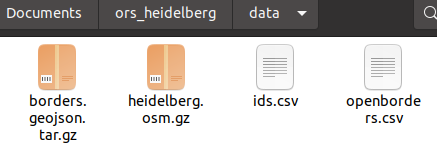
  1. I created a data folder and placed in there all the required files:
    image
    You can find all the files here: GIScience

  2. Now I adjusted the docker-compose file to the following to make the files available in docker:

version: '2.4'
services:
  ors-app:
    container_name: ors-app-hd
    ports:
      - 8088:8080
      - 9001:9001
    image: openrouteservice/openrouteservice:latest
#    build:
#      context: ../
#      args:
#        ORS_CONFIG: ./openrouteservice/src/main/resources/ors-config-sample.json
#        OSM_FILE: ./openrouteservice/src/main/files/heidelberg.osm.gz
    user: "${ORS_UID:-0}:${ORS_GID:-0}"
    volumes:
      - ./graphs:/ors-core/data/graphs
      - ./elevation_cache:/ors-core/data/elevation_cache
      - ./logs/ors:/var/log/ors
      - ./logs/tomcat:/usr/local/tomcat/logs
      - ./conf:/ors-conf
      - ./data/heidelberg.osm.gz:/ors-core/data/osm_file.pbf
      - ./data/ids.csv:/ors-core/data/ids.csv
      - ./data/openborders.csv:/ors-core/data/openborders.csv
      - ./data/borders.geojson.tar.gz:/ors-core/data/borders.geojson.tar.gz
    environment:
      - BUILD_GRAPHS=True  # Forces the container to rebuild the graphs, e.g. when PBF is changed
      - "JAVA_OPTS=-Djava.awt.headless=true -server -XX:TargetSurvivorRatio=75 -XX:SurvivorRatio=64 -XX:MaxTenuringThreshold=3 -XX:+UseG1GC -XX:+ScavengeBeforeFullGC -XX:ParallelGCThreads=4 -Xms1g -Xmx2g"
      - "CATALINA_OPTS=-Dcom.sun.management.jmxremote -Dcom.sun.management.jmxremote.port=9001 -Dcom.sun.management.jmxremote.rmi.port=9001 -Dcom.sun.management.jmxremote.authenticate=false -Dcom.sun.management.jmxremote.ssl=false -Djava.rmi.server.hostname=localhost"

Here the relevant change:

      - ./data/heidelberg.osm.gz:/ors-core/data/osm_file.pbf
      - ./data/ids.csv:/ors-core/data/ids.csv
      - ./data/openborders.csv:/ors-core/data/openborders.csv
      - ./data/borders.geojson.tar.gz:/ors-core/data/borders.geojson.tar.gz
  1. I adjusted like mention by @amandus the app.conf:
{
  "ors": {
    "info": {
      "base_url": "https://openrouteservice.org/",
      "support_mail": "support@openrouteservice.org",
      "author_tag": "openrouteservice",
      "content_licence": "LGPL 3.0"
    },
    "services": {
      "matrix": {
        "enabled": true,
        "maximum_routes": 100,
        "maximum_routes_flexible": 25,
        "maximum_search_radius": 5000,
        "maximum_visited_nodes": 100000,
        "allow_resolve_locations": true,
        "attribution": "openrouteservice.org, OpenStreetMap contributors"
      },
      "isochrones": {
        "enabled": true,
        "maximum_range_distance": [
          {
            "profiles": "any",
            "value": 50000
          },
          {
            "profiles": "driving-car, driving-hgv",
            "value": 100000
          }
        ],
        "maximum_range_time": [
          {
            "profiles": "any",
            "value": 18000
          },
          {
            "profiles": "driving-car, driving-hgv",
            "value": 3600
          }
        ],
        "fastisochrones": {
          "maximum_range_distance": [
            {
              "profiles": "any",
              "value": 50000
            },
            {
              "profiles": "driving-car, driving-hgv",
              "value": 500000
            }
          ],
          "maximum_range_time": [
            {
              "profiles": "any",
              "value": 18000
            },
            {
              "profiles": "driving-car, driving-hgv",
              "value": 10800
            }
          ],
          "profiles": {
            "default_params": {
              "enabled": false,
              "threads": 12,
              "weightings": "recommended",
              "maxcellnodes": 5000
            },
            "profile-vehicles-hgv": {
              "enabled": true,
              "threads": 12,
              "weightings": "recommended, shortest",
              "maxcellnodes": 5000
            }
          }
        },
        "maximum_intervals": 10,
        "maximum_locations": 2,
        "allow_compute_area": true
      },
      "routing": {
        "enabled": true,
        "mode": "normal",
        "routing_description": "This is a routing file from openrouteservice",
        "routing_name": "openrouteservice routing",
        "sources": [
          "data/osm_file.pbf"
        ],
        "init_threads": 1,
        "attribution": "openrouteservice.org, OpenStreetMap contributors",
        "elevation_preprocessed": false,
        "profiles": {
          "active": [
            "car"
          ],
          "default_params": {
            "encoder_flags_size": 8,
            "graphs_root_path": "data/graphs",
            "elevation_provider": "multi",
            "elevation_cache_path": "data/elevation_cache",
            "elevation_cache_clear": false,
            "instructions": true,
            "maximum_distance": 100000,
            "maximum_distance_dynamic_weights": 100000,
            "maximum_distance_avoid_areas": 100000,
            "maximum_waypoints": 50,
            "maximum_snapping_radius": 400,
            "maximum_avoid_polygon_area": 200000000,
            "maximum_avoid_polygon_extent": 20000,
            "maximum_distance_alternative_routes": 100000,
            "maximum_alternative_routes": 3,
            "maximum_distance_round_trip_routes": 100000,
            "maximum_speed_lower_bound": 80,
            "preparation": {
              "min_network_size": 200,
              "min_one_way_network_size": 200,
              "methods": {
                "lm": {
                  "enabled": true,
                  "threads": 1,
                  "weightings": "recommended,shortest",
                  "landmarks": 16
                }
              }
            },
            "execution": {
              "methods": {
                "lm": {
                  "disabling_allowed": true,
                  "active_landmarks": 8
                }
              }
            }
          },
          "profile-car": {
            "profiles": "driving-car",
            "parameters": {
              "encoder_flags_size": 8,
              "encoder_options": "turn_costs=true|block_fords=false|use_acceleration=true",
              "maximum_distance": 100000,
              "elevation": true,
              "maximum_snapping_radius": 350,
              "preparation": {
                "min_network_size": 200,
                "min_one_way_network_size": 200,
                "methods": {
                  "ch": {
                    "enabled": true,
                    "threads": 1,
                    "weightings": "fastest"
                  },
                  "lm": {
                    "enabled": false,
                    "threads": 1,
                    "weightings": "fastest,shortest",
                    "landmarks": 16
                  },
                  "core": {
                    "enabled": true,
                    "threads": 1,
                    "weightings": "fastest,shortest",
                    "landmarks": 64,
                    "lmsets": "highways;allow_all"
                  }
                }
              },
              "execution": {
                "methods": {
                  "ch": {
                    "disabling_allowed": true
                  },
                  "lm": {
                    "disabling_allowed": true,
                    "active_landmarks": 6
                  },
                  "core": {
                    "disabling_allowed": true,
                    "active_landmarks": 6
                  }
                }
              },
              "ext_storages": {
                "WayCategory": {},
                "HeavyVehicle": {},
                "WaySurfaceType": {},
                "RoadAccessRestrictions": {
                  "use_for_warnings": true
                },
				"Borders":{
					"boundaries":"/ors-core/data/borders.geojson.tar.gz",
					"ids":"/ors-core/data/ids.csv",
					"openborders":"/ors-core/data/openborders.csv"
				}
              }
            }
          },
          "profile-hgv": {
            "profiles": "driving-hgv",
            "parameters": {
              "encoder_flags_size": 8,
              "encoder_options": "turn_costs=true|block_fords=false|use_acceleration=true",
              "maximum_distance": 100000,
              "elevation": true,
              "preparation": {
                "min_network_size": 200,
                "min_one_way_network_size": 200,
                "methods": {
                  "ch": {
                    "enabled": true,
                    "threads": 1,
                    "weightings": "recommended"
                  },
                  "core": {
                    "enabled": true,
                    "threads": 1,
                    "weightings": "recommended,shortest",
                    "landmarks": 64,
                    "lmsets": "highways;allow_all"
                  }
                }
              },
              "execution": {
                "methods": {
                  "ch": {
                    "disabling_allowed": true
                  },
                  "core": {
                    "disabling_allowed": true,
                    "active_landmarks": 6
                  }
                }
              },
              "ext_storages": {
                "WayCategory": {},
                "HeavyVehicle": {
                  "restrictions": true
                },
                "WaySurfaceType": {}
              }
            }
          },
          "profile-bike-regular": {
            "profiles": "cycling-regular",
            "parameters": {
              "encoder_options": "consider_elevation=true|turn_costs=true|block_fords=false",
              "elevation": true,
              "ext_storages": {
                "WayCategory": {},
                "WaySurfaceType": {},
                "HillIndex": {},
                "TrailDifficulty": {}
              }
            }
          },
          "profile-bike-mountain": {
            "profiles": "cycling-mountain",
            "parameters": {
              "encoder_options": "consider_elevation=true|turn_costs=true|block_fords=false",
              "elevation": true,
              "ext_storages": {
                "WayCategory": {},
                "WaySurfaceType": {},
                "HillIndex": {},
                "TrailDifficulty": {}
              }
            }
          },
          "profile-bike-road": {
            "profiles": "cycling-road",
            "parameters": {
              "encoder_options": "consider_elevation=true|turn_costs=true|block_fords=false",
              "elevation": true,
              "ext_storages": {
                "WayCategory": {},
                "WaySurfaceType": {},
                "HillIndex": {},
                "TrailDifficulty": {}
              }
            }
          },
          "profile-bike-electric": {
            "profiles": "cycling-electric",
            "parameters": {
              "encoder_options": "consider_elevation=true|turn_costs=true|block_fords=false",
              "elevation": true,
              "ext_storages": {
                "WayCategory": {},
                "WaySurfaceType": {},
                "HillIndex": {},
                "TrailDifficulty": {}
              }
            }
          },
          "profile-walking": {
            "profiles": "foot-walking",
            "parameters": {
              "encoder_options": "block_fords=false",
              "elevation": true,
              "ext_storages": {
                "WayCategory": {},
                "WaySurfaceType": {},
                "HillIndex": {},
                "TrailDifficulty": {}
              }
            }
          },
          "profile-hiking": {
            "profiles": "foot-hiking",
            "parameters": {
              "encoder_options": "block_fords=false",
              "elevation": true,
              "ext_storages": {
                "WayCategory": {},
                "WaySurfaceType": {},
                "HillIndex": {},
                "TrailDifficulty": {}
              }
            }
          },
          "profile-wheelchair": {
            "profiles": "wheelchair",
            "parameters": {
              "encoder_options": "block_fords=true",
              "elevation": true,
              "maximum_snapping_radius": 50,
              "ext_storages": {
                "WayCategory": {},
                "WaySurfaceType": {},
                "Wheelchair": {
                  "KerbsOnCrossings": "true"
                },
                "OsmId": {}
              }
            }
          }
        }
      }
    },
    "logging": {
      "enabled": true,
      "level_file": "DEBUG_LOGGING.json",
      "location": "/var/log/ors",
      "stdout": true
    },
    "system_message": [
      {
        "active": false,
        "text": "This message would be sent with every routing bike fastest request",
        "condition": {
          "request_service": "routing",
          "request_profile": "cycling-regular,cycling-mountain,cycling-road,cycling-electric",
          "request_preference": "fastest"
        }
      },
      {
        "active": false,
        "text": "This message would be sent with every request for geojson response",
        "condition": {
          "api_format": "geojson"
        }
      },
      {
        "active": false,
        "text": "This message would be sent with every request on API v1 from January 2020 until June 2050",
        "condition": {
          "api_version": 1,
          "time_after": "2020-01-01T00:00:00Z",
          "time_before": "2050-06-01T00:00:00Z"
        }
      },
      {
        "active": false,
        "text": "This message would be sent with every request"
      }
    ]
  }
}

Here the adjusted part:

"ext_storages": {
                "WayCategory": {},
                "HeavyVehicle": {},
                "WaySurfaceType": {},
                "RoadAccessRestrictions": {
                  "use_for_warnings": true
                },
				"Borders":{
					"boundaries":"/ors-core/data/borders.geojson.tar.gz",
					"ids":"/ors-core/data/ids.csv",
					"openborders":"/ors-core/data/openborders.csv"
				}
              }
  1. Then I trigger docker-compose up -d

  2. You can validate the avoid border feature with the following test calls:

Without avoid borders

curl -X POST \
  'http://localhost:8088/ors/v2/directions/driving-car' \
  -H 'Content-Type: application/json; charset=utf-8' \
  -H 'Accept: application/json, application/geo+json, application/gpx+xml, img/png; charset=utf-8' \
  -d '{"coordinates":[[8.69220892604095,49.41426934481985],[8.689622708880878,49.39705221373453]]}' 

And with the avoid border:

curl -X POST \
  'http://localhost:8088/ors/v2/directions/driving-car' \
  -H 'Content-Type: application/json; charset=utf-8' \
  -H 'Accept: application/json, application/geo+json, application/gpx+xml, img/png; charset=utf-8' \
  -d '{"coordinates":[[8.69220892604095,49.41426934481985],[8.689622708880878,49.39705221373453]],"options":{"avoid_borders":"all"}}'

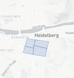
The second call returns a longer driving time because he needs to route around the following borders of the sample data:

image

@amandus Thank you a lot for your help.