Hi, so I would like to know if there is a place that shows the coverage details for each country.
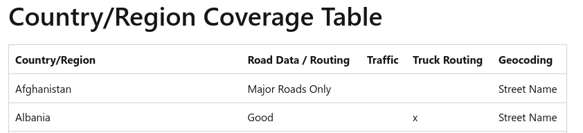
Bingmaps has its rating by good, fair or major roads only.
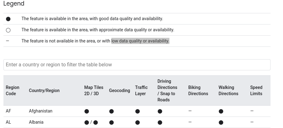
For Google Maps its rating by good data quality and availability, approximate data quality or availability or low data quality or availability.
GM: Google Maps Platform Coverage Details | Google for Developers
Bing: Bing Maps Geographic Coverage - Microsoft Bing Maps | Microsoft Learn
Hi everyone.
I’m here because it’s been 21d since I’ve posted it and with no response.
If someone has any info to help me I would appreciate it.
Thank you
Hi @ophmariano,
for our routing engine this comes down to OpenStreetMap(OSM) data coverage.
I couldn’t find any existing extrinsic (e.g. comparison with other ground truth data) country level coverage for OSM data.
The coverage of course also depends on your use case. If you would like to do HGV routing for example, it doesn’t help much if all the roads are there but attributes for max_width/max_height and similar are missing. So best you always make sure the data fits your use case regardless of some coverage indicator.
However, we are developing some solutions in that direction. Take a look at the ohsome quality analyst that offers several quality indicators and can be run for other regions by using the API:
https://oqt.ohsome.org
https://oqt.ohsome.org/api/docs
For the road network there are currently only intrinsic indicators available (mapping saturation, up-to-dateness,…).
For Google and Bing Maps i also couldn’t get what methodology they use to calculate their coverage. Although Bing provides a bit more info on the categories, i am also missing what they are comparing their data to.
Hope this helps a bit.
Best regards
1 Like
Hey @amandus, hope that you’re doing well and thank you for the replay it was a perfect fit.
Thank you for the extra input, I’ll take it into consideration.
Best regards
1 Like