Navigation for agricultural

Hi,

I am maybe trying to solve kind of an edge-case here: Build a quick navigation for my agricultural-vehicle. Driving to distance places implies that certain roads can’t be used by agricultural-vehicle because they are too slow and / or not allowed there (DE).

If possible I would like to calculate a route considering those limitations. The OpenStreetMap-Wiki seem to offer certain ways to archive that:
https://wiki.openstreetmap.org/wiki/DE:Key:agricultural

https://wiki.openstreetmap.org/wiki/Tag:access%3Dagricultural

Unfortunately I am a bit lost on how to implement that in terms of the openrouteservice-API within the API Playground (Dircetions),

Maybe someone could provide me with an example on how to do this on the API-Playground?
Is what I am trying todo here even possible?

Hi @Hela,

there is a dedicated agricultural profile in our api.
You have to set the profile to driving-hgv and then choose agricultural within options.vehicle_type or just set the body like this if you are using the api directly

{"coordinates":[[...],[...]],"options":{"vehicle_type":"agricultural"}}

I’m not sure to what extent it will respect the agricultural tags though, as it is a rarely used profile and therefore does not get much feedback.

Best regards

Hi @amandus,
thanks for you reply - this is exactly what I did in the first place. Unfortunately the profile does not reflect those restrictions. Let me show you an example:
https://classic-maps.openrouteservice.org/directions?n1=50.470849&n2=9.712837&n3=15&a=50.471175,9.711618,50.51916,9.681722&b=4d&c=0&k1=en-US&k2=km

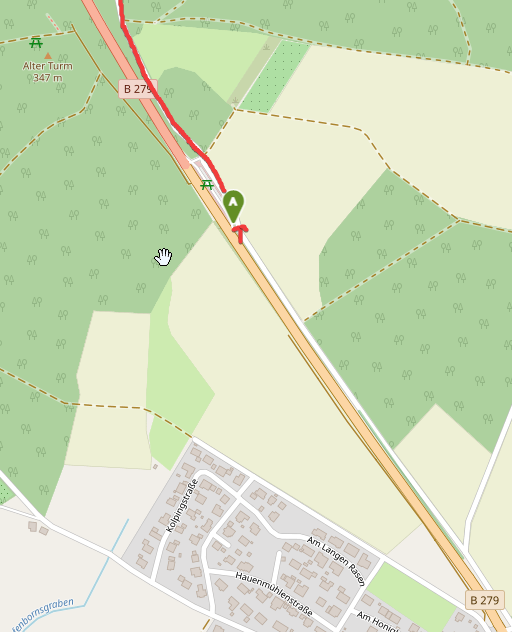
At a certain point there is an restriction in place shortly after the parking area behind “Rothemann”, which forbirds the use of agricultural-vehicle on B279 (so you have to leave through the parking area at that point). The exact point would be:
50.47599,9.69520


The Ristriction in place here is called “Kraftfahrtstraße” in Germany (traffic_sign=DE:331.1).

Due to my limited knowledge regarding OpenStreetMaps I am not sure if this limitation is even part of the map-material?

The given road is properly tagged in OSM with motorroad=yes, see https://overpass-turbo.eu/s/15OZ. However, it seems that the logic to restrict agricultural vehicles on these type of roads is missing in our backend. Feel free to file an issue.

Cheers,
Andrzej