# Cannot cross a specific hiking path + several tracks on a single map
**URL:** https://ask.openrouteservice.org/t/cannot-cross-a-specific-hiking-path-several-tracks-on-a-single-map/2665
**Category:** Maps Website
**Created:** [April 6, 2021, 4:30pm UTC](https://ask.openrouteservice.org/t/cannot-cross-a-specific-hiking-path-several-tracks-on-a-single-map/2665 "2021-04-06T16:30:32Z")
**Posts on this page:** 9
**Page:** 1
### Author:  [@zerodeux](https://ask.openrouteservice.org/u/zerodeux)
#### Post date: [April 6, 2021, 4:30pm UTC](https://ask.openrouteservice.org/t/cannot-cross-a-specific-hiking-path-several-tracks-on-a-single-map/2665/1 "2021-04-06T16:30:32Z")
Hello there,
I love the OpenRouteService for hiking, it’s fantastic and very well designed.
I’ve recently hit a problem I don’t know how to debug : going
- from 5.591827071974965, 45.392837235567754
- to 5.5923901845710775, 45.39302558760163
… is not possible with ORS in hiking profile (it takes a whopping \>2km workaround instead of a straight 50m!) but paths seem to be connected, and I’ve physically walked on this path, it’s fine. Would you know what’s happening ?
Also I was wondering if I could created disjoints tracks on a single map (which would work around the previous problem), with a feature like “Create new starting point” ?
---
### Author:  [@amoncaldas](https://ask.openrouteservice.org/u/amoncaldas)
#### Post date: [April 6, 2021, 4:57pm UTC](https://ask.openrouteservice.org/t/cannot-cross-a-specific-hiking-path-several-tracks-on-a-single-map/2665/2 "2021-04-06T16:57:22Z")
Hi @zerodeux
Thanks for reaching us.
I tested your case and indeed, it is not routing through a route that is visibly there on the map. The thing is that this seems not to be an issue related to the maps client app, but some missing/wrong data about routable path on OSM database or eventually some minor issue on the ORS back-end. Maybe @andrzej can help us to understand it better.
Regarding disjoints tracks, it is currently not supported. It is not on our top priority list, but if you want to suggest it (give more details) on our github repo [GitHub - GIScience/ors-map-client: Openrouteservice API web SPA client using VueJS, Vuetify and Vue2Leaflet](https://github.com/GIScience/ors-map-client) and other people back it, than we can analyze the possibility of implementing it .
Cheers,
Amon
---
### Author:  [@adam](https://ask.openrouteservice.org/u/adam)
#### Post date: [April 7, 2021, 7:57am UTC](https://ask.openrouteservice.org/t/cannot-cross-a-specific-hiking-path-several-tracks-on-a-single-map/2665/3 "2021-04-07T07:57:21Z")
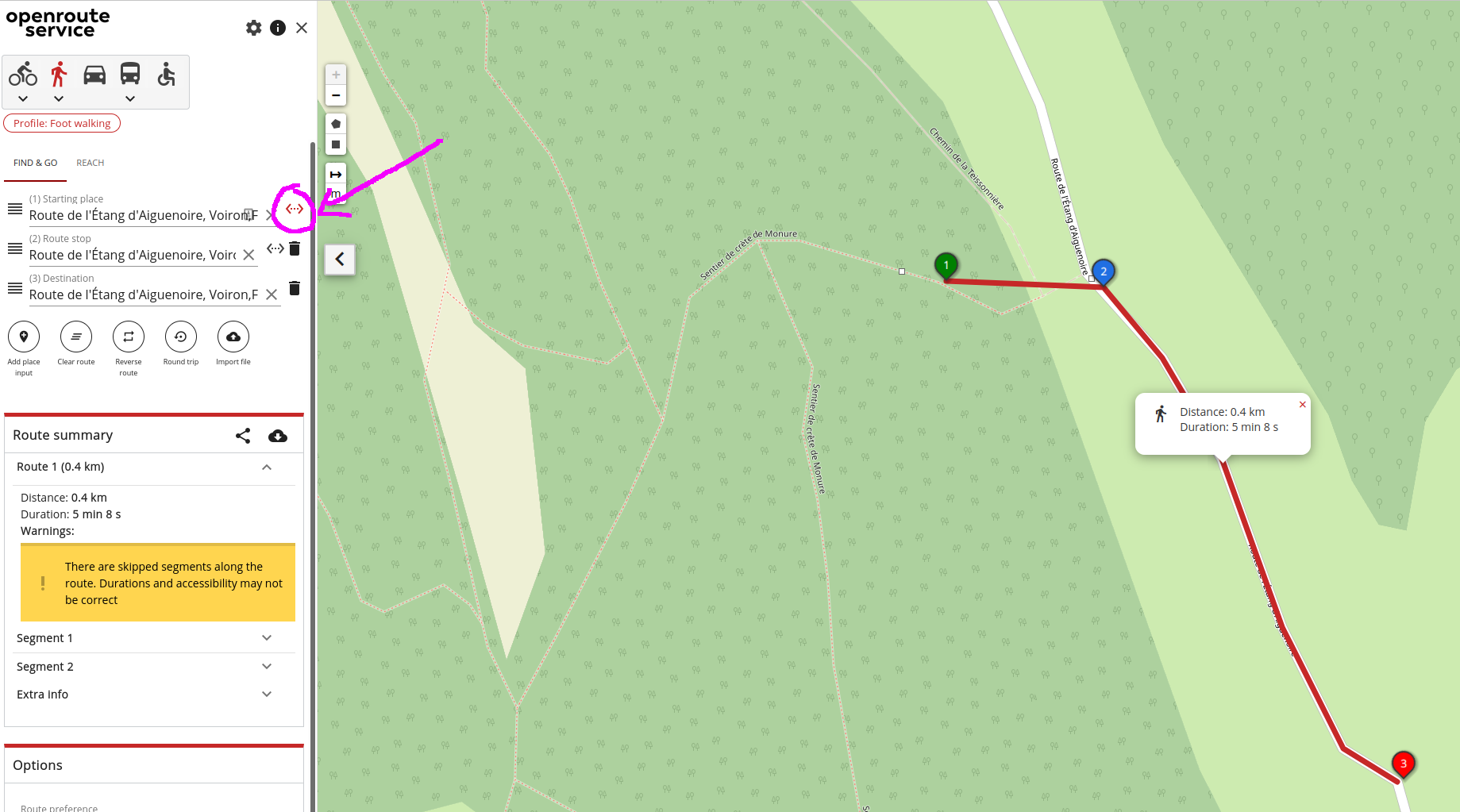
As a way around this for now, you can use the “direct segment” functionality which in effect tells routing to not generate a route for a specific segment between two points
---
### Author:  [@amandus](https://ask.openrouteservice.org/u/amandus)
#### Post date: [April 7, 2021, 8:50am UTC](https://ask.openrouteservice.org/t/cannot-cross-a-specific-hiking-path-several-tracks-on-a-single-map/2665/4 "2021-04-07T08:50:50Z")
Hi @zerodeux,
I guess the problem is the `access:no` tag.
See the osm wiki for that tag: [Key:access - OpenStreetMap Wiki](https://wiki.openstreetmap.org/wiki/Key:access)
> **[Way: Chemin de la Teissonnière (242480325) | OpenStreetMap](https://www.openstreetmap.org/way/242480325#map=17/45.39486/5.58998)**
>
> OpenStreetMap is a map of the world, created by people like you and free to use under an open license.
If the access restriction is not specific to one vehicle/ transportation type. it will be avoided in general
---
### Author:  [@zerodeux](https://ask.openrouteservice.org/u/zerodeux)
#### Post date: [April 7, 2021, 1:41pm UTC](https://ask.openrouteservice.org/t/cannot-cross-a-specific-hiking-path-several-tracks-on-a-single-map/2665/5 "2021-04-07T13:41:00Z")
Thanks for you quick answer. I just learned how to query features on OSM, now it makes sense.
I’ll have a closer look the next time I follow this track and see if this access:no tag is still valid (I did not cross any forbidden or private property sign), and maybe fix it.
---
### Author:  [@zerodeux](https://ask.openrouteservice.org/u/zerodeux)
#### Post date: [April 7, 2021, 3:19pm UTC](https://ask.openrouteservice.org/t/cannot-cross-a-specific-hiking-path-several-tracks-on-a-single-map/2665/6 "2021-04-07T15:19:21Z")
Thanks @adam, that’s exactly what I was looking for !
---
### Author:  [@zerodeux](https://ask.openrouteservice.org/u/zerodeux)
#### Post date: [April 7, 2021, 3:24pm UTC](https://ask.openrouteservice.org/t/cannot-cross-a-specific-hiking-path-several-tracks-on-a-single-map/2665/7 "2021-04-07T15:24:19Z")
Thanks @amoncaldas , the workaround (direct segment) suggest by @adam fixed my problem. But I must say that the ability to “superpose” several trips on a single map has more than often itched me, maybe I’ll try a UI proposal. Thanks for the quick feedback !
---
### Author:  [@chilobo](https://ask.openrouteservice.org/u/chilobo)
#### Post date: [April 30, 2022, 11:55am UTC](https://ask.openrouteservice.org/t/cannot-cross-a-specific-hiking-path-several-tracks-on-a-single-map/2665/8 "2022-04-30T11:55:29Z")
I have a similar problem:
tracking from
49.70763272987024; 8.717055951229684
to
49.706328261320884; 8.717356320545184
is possible on foot, but not by bike.
The trick from adam helps.
Could it be that I just have to change the value of the tag vehicle from private to forestry of the road in OSM?
Or do I have to add bicycle yes?
---
### Author:  [@jschnell](https://ask.openrouteservice.org/u/jschnell)
#### Post date: [May 2, 2022, 6:59am UTC](https://ask.openrouteservice.org/t/cannot-cross-a-specific-hiking-path-several-tracks-on-a-single-map/2665/9 "2022-05-02T06:59:20Z")
Hey,
regarding the question which tags lead to a way being available for a certain profile or not, have a look at [our backend doumentation](https://giscience.github.io/openrouteservice/documentation/Tag-Filtering.html).
Note, that it will take some time until the changes are reflected in the ors.
Best regards