# Bug Routing Over a River
**URL:** https://ask.openrouteservice.org/t/bug-routing-over-a-river/1830
**Category:** openrouteservice
**Created:** [June 19, 2020, 10:44pm UTC](https://ask.openrouteservice.org/t/bug-routing-over-a-river/1830 "2020-06-19T22:44:34Z")
**Posts on this page:** 7
**Page:** 1
### Author:  [@Fernando](https://ask.openrouteservice.org/u/Fernando)
#### Post date: [June 19, 2020, 10:44pm UTC](https://ask.openrouteservice.org/t/bug-routing-over-a-river/1830/1 "2020-06-19T22:44:34Z")
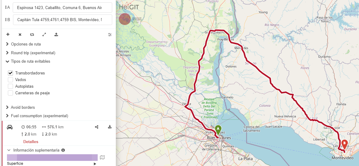
If I try to route from Buenos Aires, Argentina to Montevideo, Uruguay, the route is passing over the river, and this is not the correct rout, its impossible to drive over the river!
Here is the link:
[https://maps.openrouteservice.org/directions?n1=-34.602531&n2=-57.30236&n3=9&a=-34.607357,-58.454595,-34.822559,-56.15736&b=0&c=0&k1=en-US&k2=km](https://maps.openrouteservice.org/directions?n1=-34.602531&n2=-57.30236&n3=9&a=-34.607357,-58.454595,-34.822559,-56.15736&b=0&c=0&k1=en-US&k2=km)
If I try the same route, in the inverse direction (from Montevideo to Buenos Aires) is working right:
[https://maps.openrouteservice.org/directions?n1=-33.931224&n2=-57.601682&n3=8&a=-34.822559,-56.15736,-34.607357,-58.454595&b=0&c=0&k1=en-US&k2=km](https://maps.openrouteservice.org/directions?n1=-33.931224&n2=-57.601682&n3=8&a=-34.822559,-56.15736,-34.607357,-58.454595&b=0&c=0&k1=en-US&k2=km)
I don’t know what’s the cause of this bug
---
### Author:  [@nils](https://ask.openrouteservice.org/u/nils)
#### Post date: [June 20, 2020, 7:18am UTC](https://ask.openrouteservice.org/t/bug-routing-over-a-river/1830/2 "2020-06-20T07:18:40Z")
I won’t look into it in detail now, but there’s obviously a ferry. My guess is that from Buenos Aires to Montevideo, cars are allowed, but not the other way around.
Have a look at the tagging of the ferry on [https://openstreetmap.org](https://openstreetmap.org) and update the tags according to reality. Within a few weeks you’ll see the change in our routing engine.
---
### Author:  [@Fernando](https://ask.openrouteservice.org/u/Fernando)
#### Post date: [June 26, 2020, 12:39pm UTC](https://ask.openrouteservice.org/t/bug-routing-over-a-river/1830/3 "2020-06-26T12:39:27Z")
Thank You Nils
The ferry works in both directions
I don’t know how to update the tags
---
### Author:  [@amandus](https://ask.openrouteservice.org/u/amandus)
#### Post date: [June 26, 2020, 12:57pm UTC](https://ask.openrouteservice.org/t/bug-routing-over-a-river/1830/4 "2020-06-26T12:57:41Z")
@Fernando,
Here is a simple tutorial to editing osm [https://learnosm.org/es/beginner/id-editor/](https://learnosm.org/es/beginner/id-editor/)
This is probably due to this [https://www.openstreetmap.org/relation/8339933#map=18/-34.47427/-57.84252](https://www.openstreetmap.org/relation/8339933#map=18/-34.47427/-57.84252)
or the barriers(gates) along this geometry.
see [https://maps.openrouteservice.org/directions?n1=-34.473729&n2=-57.842275&n3=18&a=-34.47321,-57.843586,-34.473723,-57.843672&b=0&c=0&k1=en-US&k2=km](https://maps.openrouteservice.org/directions?n1=-34.473729&n2=-57.842275&n3=18&a=-34.47321,-57.843586,-34.473723,-57.843672&b=0&c=0&k1=en-US&k2=km)
I’m not sure on what the actual problematic thing is, or what tags would work in this case
Maybe @adam @andrzej @nils can help further
---
### Author:  [@adam](https://ask.openrouteservice.org/u/adam)
#### Post date: [June 26, 2020, 1:07pm UTC](https://ask.openrouteservice.org/t/bug-routing-over-a-river/1830/5 "2020-06-26T13:07:17Z")
Yes, reason it only goes the one way on the ferry is because of one way restrictions and gates on the roads that connect to the terminal in Colonia del Sacramento.
So according to the network, there is no way to get to the start of the ferry there without breaking road laws or going through a barrier
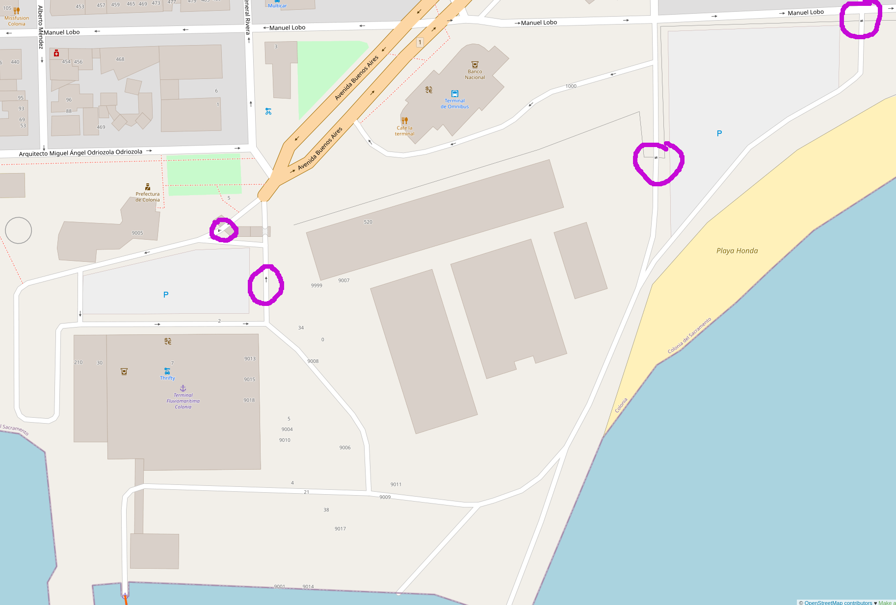
(the highlighted one way road goes all the way up to the main road)
---
### Author:  [@adam](https://ask.openrouteservice.org/u/adam)
#### Post date: [June 26, 2020, 1:33pm UTC](https://ask.openrouteservice.org/t/bug-routing-over-a-river/1830/6 "2020-06-26T13:33:39Z")
In terms of updating the OSM, I believe the correct way would be to update the lift gate (left most highlighted feature) to identify that vehicles can pass through it (I guess that this is a controlled gate for the parking or something). According to the Wiki ([Key:access - OpenStreetMap Wiki](https://wiki.openstreetmap.org/wiki/Key:access)) it seems that adding `access=yes` to that lift gate would do the trick.
Realistically though it should be someone who knows that area that actually updates the data to reflect the real world usage as it is impossible to know for sure without having experience of the feature itself.
> **[Node: 1496231089 | OpenStreetMap](https://www.openstreetmap.org/node/1496231089)**
>
> OpenStreetMap is a map of the world, created by people like you and free to use under an open license.
---
### Author:  [@Fernando](https://ask.openrouteservice.org/u/Fernando)
#### Post date: [June 26, 2020, 1:51pm UTC](https://ask.openrouteservice.org/t/bug-routing-over-a-river/1830/7 "2020-06-26T13:51:43Z")
Thank you all
I found a correct solution to this problem
If I check the option “Avoid Ferries”, the route looks good
I know the area, I travel by Ferry from Buenos Aires to Colonia and from Buenos Aires to Montevideo. Both routes can be completed by ferry, but not by car, because there is the river plate between this cities. There are no bridges or something similar, you can travel directly by ferry or by car, but with a long detour to Entre Ríos: